HAGUPIT/Ruby – 900 hPa – EXTREME !!!

Super Typhoon HAGUPIT/Ruby’s central is going down to incredible 900 hPa !!! Only 5 hPa from HAIYAN/Yolanda. The forward speed is slowing down from 31 to 20 km/h. Beware of this extremely catastrophic cyclone!
The Multi Agency Forecast
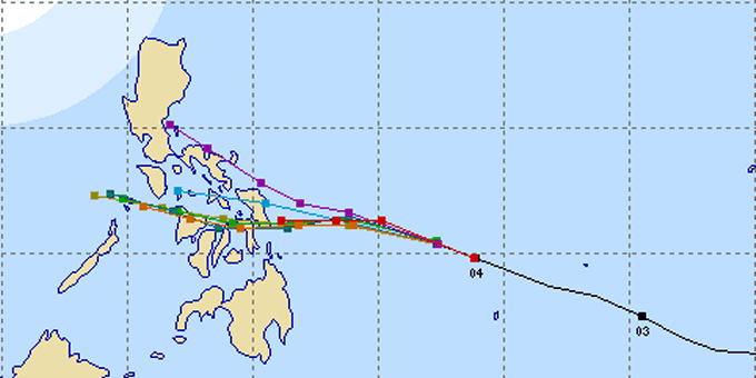
The US Navy went a bit south-west, the Asian agencies moved a bit north and PAGASA stays somewhere in the middle. Choose your favorite track! Nobody knows at this moment. This is really the silliest situation I’ve experienced in the last 7 years.
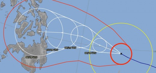
The JMA track forecast
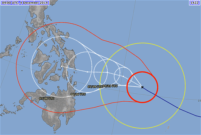
JMA moves north a notch. Bohol isn’t menaced directly anymore. Negros could also escape of the worst impact. But southern Samar, Leyte, Cebu and probably Panay will get hit violently. The size of the bold red 50 kt = 90 km/h wind area is very large.
Super Typhoon HAGUPIT/Ruby Storm data
| Name (INTL. / local): | HAGUPIT/Ruby |
| Class: | Super Typhoon Cat.5 |
| Time/Date of observation: | 06:00 PM on December 4, 2014 |
| Location of Center: | 10.7º North 131.9º East |
| Moving Direction and Speed: | West – Northwest @ 25 km/h |
| Moving towards: | Leyte / Samar |
| Distance from the Philippines: | 600 km E of Surigao |
| Estimated Date / Time of Landfall: | Saturday / Sunday |
| Max. Wind Speed near Center: | 212 km/h |
| Peak Wind Gusts: | 305 km/h |
| Minimum Central Pressure: | 905 hPa |
| Diameter: | 990 km |
| 24h Rainfall near Center: | 150 – 400 mm |
| Max. Wave Height: | 10 – 15 m |
| Here you find how to read and understand this data | |
Next update tomorrow morning before breakfast!
Almost real-time storm information
[GARD]
Related posts
 December 6, 2014 Super Typhoon HAGUPIT/Ruby – final approach Super Typhoon HAGUPIT/Ruby - final approach. The typhoon maintained its strength with 925 hPa central pressure. It also maintained its […]
- December 5, 2014 HAGUPIT/Ruby – Samar again Super Typhoon HAGUPIT/Ruby will hit Samar again - this is now sure. JMA forecasts rather the southeastern shores and JTWC predicts the […]
- December 4, 2014 Super Typhoon HAGUPIT/Ruby – I stay with JMA Super Typhoon HAGUPIT/Ruby - I stay with JMA. The battle between the typhoon track forecasters makes higher waves than the typhoon. After […]
- December 4, 2014 Typhoon HAGUPIT/Ruby – the tracks spread Typhoon HAGUPIT/Ruby – the tracks spread now more and more. The southernmost and fastest track is maintained by Japan's JMA. US's JTWC on […]
- September 23, 2012 Severe Tropical Storm “JELAWAT / Lawin” slowly turns North Tropical Storm “JELAWAT / Lawin” has again intensified and is now a Severe Tropical Storm.
“JELAWAT / Lawin” is now slowly […]


Recent Comments