Landfall over Casiguran – Aurora
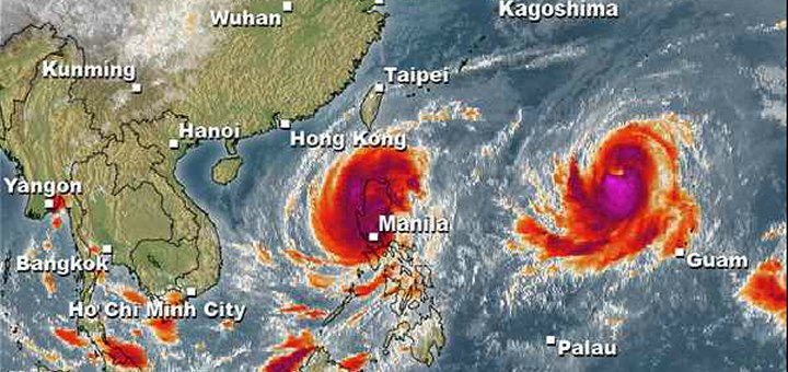
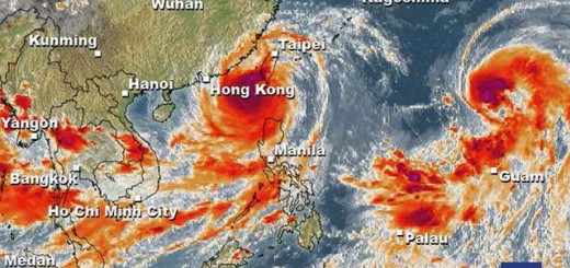
Super Typhoon KOPPU/Lando has made Landfall between Baler and Casiguran in Aurora province around 01:00 a.m. this morning. Cyclonic winds had previously reached speeds of over 200 km/h. Forward speed has completely broken down and is only 3 km/h at this moment.
Here in Camiguin, 820 km south-east of Aurora, we encounter gusty winds and high waves. But at least it is sunny. And we need the sun, because power has again broken down around 4 a.m.
Shortly before cyclone KOPPU/Lando had reached the cost it had again intensified and had been upgraded to a Super Typhoon Category 4. As forecasters predicted, the forward speed of the storm has now completely broken down. It is currently estimated to be only 3 km/h in western direction.
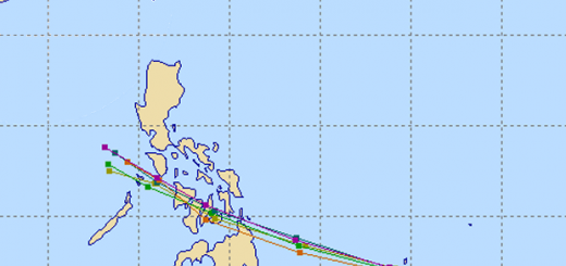
Super Typhoon KOPPU/Lando track forecast
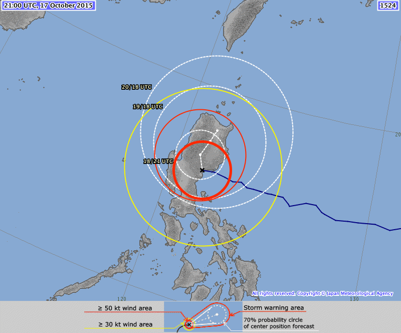
All agencies predict that KOPPU/Lando will stay over northern Luzon during 2 to 3 days.
Project Noah is a great help

The website of DOST’s Project Noah is now working well. Above we’ve put the layers of the 3 Doppler Radars in Aparri, Subic and Baler. Radars that use the Doppler effect can measure the density of humidity and rainfall at large distance. Have a look into Project Noah.
PAGASA Storm Signals
Storm Signal #4: winds of 171 to 220 kph within 12 hours
Aurora
Storm Signal #3: winds of 121 to 170 kph within 18 hours
Isabela, Quirino, Nueva Vizcaya, Nueva Ecija, Ifugao, Northern Quezon including Polillo Islands
Storm Signal #2: winds of 61 to 120 kph within 24 hours
Cagayan including Calayan and Babuyan group of Islands, Benguet, Mt. Province, Abra, Kalinga, Apayao, Pangasinan, La Union, Ilocos Sur, Ilocos Norte, Bulacan, Pampanga, Tarlac, Rizal, rest of Quezon, Camarines Norte, Metro Manila
Storm Signal #1: winds of 30 to 60 kph within 36 hours
Batanes, Zambales, Bataan, Cavite, Laguna, Batangas, Albay, Camarines Sur, Catanduanes
KOPPU/Lando Storm data:
| Name (INTL. / local): | KOPPU/Lando |
| Class: | Super Typhoon Category 4 |
| Time/Date of observation: | 05:00 AM on October 18, 2015 |
| Location of Center: | 16.0° North 121.5° East |
| Moving Direction and Speed: | West @ 3 km/h !!! |
| Moving towards: | Northern Luzon |
| Distance from the Philippines: | Over Baler (Aurora) |
| Estimated Date / Time of Landfall: | This morning @ 1 a.m. |
| Max. Wind Speed near Center: | 175 km/h |
| Peak Wind Gusts: | 230 km/h |
| Minimum Central Pressure: | 920 hPa |
| Diameter: | 850 km |
| 24h Rainfall near Center: | 100 – 500 mm |
| Max. Wave Height: | Extreme storm surge!!! |
| Here you find how to read and understand this data | |
Nearly real-time storm information
Next update when power will be back.
[GARD]
Related posts
 October 17, 2015 Great Danger in Aurora – Typhoon KOPPU/Lando now Cat.4 Great Danger in Aurora - Typhoon KOPPU/Lando has now developed an eye and has been upgraded to Category 4. PAGASA has hoisted Storm SIgnal […]
- October 18, 2015 Too slow! Typhoon KOPPU/Lando creeps over land Too slow! Typhoon KOPPU/Lando moves only very slowly northwest. Forward speeds are between 3 and 9 km/h! The Typhoon continues to bring […]
- October 17, 2015 Typhoon KOPPU/Lando now Category 3 Typhoon KOPPU/Lando gained strength and is now a Typhoon Category 3. The cyclone has slowly approached the Philippines and is now 285 km […]
- October 16, 2015 Typhoon KOPPU/Lando is now affecting the Philippines Typhoon KOPPU/Lando is already near and upgraded to Cat.2. PAGASA sees it 510 km off the coast of Aurora. The strong winds and heavy […]
- October 16, 2015 Typhoon KOPPU/Lando brings first heavy rains Typhoon KOPPU/Lando brings the first heavy rains to the Philippines. Winds on the north-east coast are now stronger than 30 knots (55 […]


Recent Comments