Mayon Volcano Alert Level 2

Mayon Volcano Alert Level has been lowered to Level 2. PHIVOLCS noted a “general decline” of the volcano’s overall activity since the last recorded seismic swarm last November 29.
PHIVOLCS maintain their warning to the public to avoid entry into the six-kilometer permanent danger zone around Mayon Volcano due to the hazards of rockfalls, avalanche, ash puffs and sudden steam-driven or phreatic eruptions at the summit area. The lowering of the Alert Level from 3 to 2 should not be taken to mean the volcano’s unrest has ceased, saying eruptible magma has already accumulated deeper beneath it.
This lowering of the Alert Level is good news for the nearly 3,000 families evacuated from their homes earlier this year. Families whose houses are outside the 6 kilometer permanent danger zone around Mayon Volcano are allowed to return.
Those families whose houses are inside this danger zone will be permanently relocated. Priority in the relocation program will be given to those in the southeast quadrant including Camalig and Daraga.
Mayon Volcano Hazard maps


Click on the thumbnails to enlarge
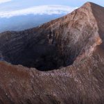
Mayon Volcano is the Philippines’ most active volcano and is considered to be the world’s most perfectly formed volcano for its symmetrical cone. It is a basaltic-andesitic volcano.
The upper slopes of the volcano are steep averaging 35-40 degrees and are capped by a small summit crater. Its sides are layers of lava and other volcanic material. Mayon has had forty-seven eruptions in recorded history.
The first recorded eruption was in 1616, the last major eruption ceased on 1st October 2006, although a devastating lahar followed on 30 November 2006.
The most destructive eruption of Mayon occurred on February 1, 1814. Lava flowed but not as much compared to the 1766 eruption.
PHIVOLCS is closely monitoring Mayon Volcano and any new development will be relayed to all concerned.
See also our volcano page and hot volcano page
Title photo courtesy of James Jacob.
[GARD]
Related posts
 December 5, 2016 Kanlaon Volcano – outstanding movie by NAVA Kanlaon Volcano is the dominating mountain of Negros island.
Kanlaon Volcano in the north-east and Talinis Volcano in the south-west have […]
December 5, 2016 Kanlaon Volcano – outstanding movie by NAVA Kanlaon Volcano is the dominating mountain of Negros island.
Kanlaon Volcano in the north-east and Talinis Volcano in the south-west have […]- May 4, 2015 Tropical Storm NOUL The Tropical Depression seen end of last week got stronger and better organized. Tropical Storm NOUL is currently moving slowly […]
- December 1, 2014 “The View” Camiguin "The View" Camiguin is the newest restaurant on our little island. We went here yesterday. It had been a gray and cloudy day. "The View" […]
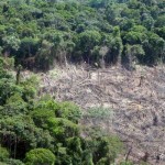
- May 30, 2012 Forest conservation vs. illegal logging Illegal logging and legal over-logging are one of the big problems in the Philippines. Before a tree is cut, it has three extremely […]
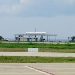
- November 5, 2014 Laguindingan Airport being tested right now Laguindingan Airport is being tested right now. DOTC and CAAP are testing the electronics and lights in RPML/CGY from November 4 to […]


Recent Comments