Severe Tropical Storm PHANFONE/Ursula – update
Severe Tropical Storm PHANFONE/Ursula found favorable conditions last night and did increase its strength. The central pressure went down to 985 hPa (from 998 hPa).
JMA’s forecast stays on 985 hPa until December 26, 00:00 (UTC). Then it will again increase to 990 hPa on December 27 and to 998 hPa on Dember 28.
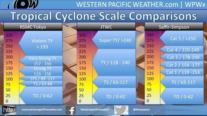
The US Navy already declares Typhoon Cat. 1! Why?
The different meteorological agencies use different scales to classify cyclones. Here is a comparison between JMA and JTWC with the classic Saffir-Simpson scale:
Copyright by www.westernpacificweather.com
JMA is the only agency to use the category Severe Tropical Storm. The trigger to Typhoon Cat.1 is at 118/119 km/h. So it’s a speed difference of 1 km/h or 0.62 mph that makes a Typhoon.
To make things worse, Hong Kong and the Philippine’s PAGASA do have their own scales: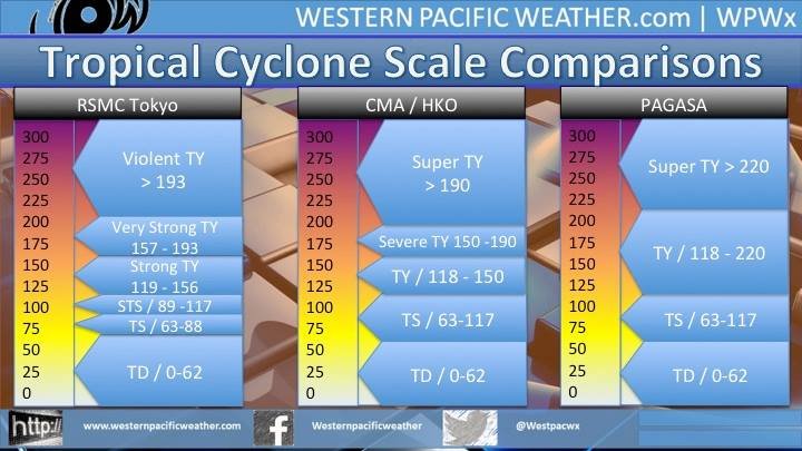 Copyright by www.westernpacificweather.com
Severe Tropical Storm PHANFONE/Ursula – what now?
Landfall is expected along Borongan City – Hernani Area (Eastern Samar), between 7 to 8 PM local time tonight (Christmas Eve). Now, the conditions on the last 100 kilometers before landfall will decide about the intensity. Unfortunately the water temperature off the coast of southern Samar is high. With 28 to 29 degrees Celsius, 82 to 84 Fahrenheit, the storm can replenish with energy.
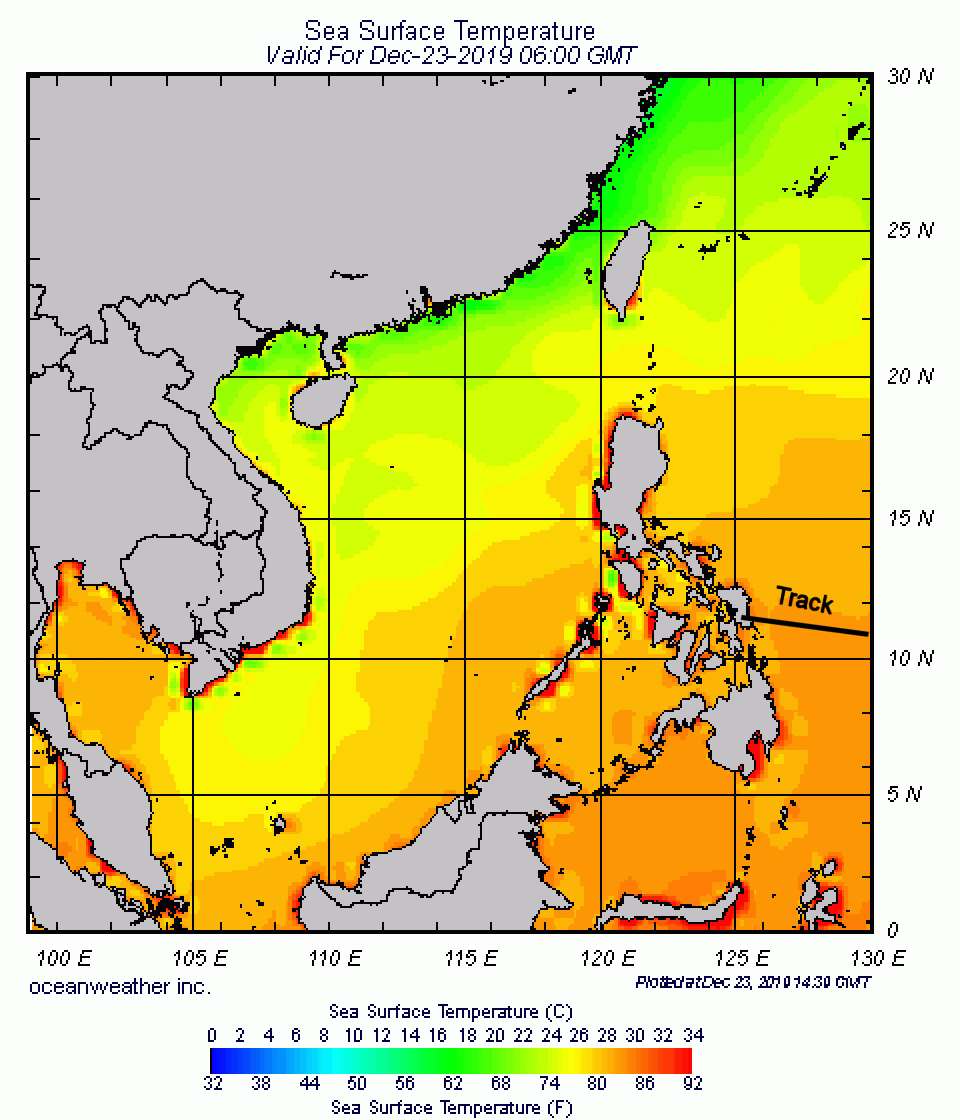
Meanwhile (at 2:00 PM PST) the weather has changed. Over the Bohol Sea the wind direction has changed from east to west. This is because the cyclone sucks the air on its southern end from west. The sky is uniform grey without any structure and the air temperature fell down to 26°C (29°F). It is slightly raining in Camiguin.
A word to the critics
On social media I had been accused to diffuse fake information. I don’t think so. Yesterday the central pressure stayed in the 990 hPa. In the following night it then went down to 985 hPa. a pressure difference of some few Hecto-Pascal is extremely difficult to predict.
For now 13 years I rely on the weather data from JMA. The Japan Meteorological Agency is known to be very precise. They stay cool, when others announce a coming horror storm. Also they report in a stoic language without the use of superlatives. Their extremest typhoon category is “violent”. Also in the future I will stay with JMA.
[GARD]
Related posts
 March 31, 2015 Super Typhoon MAYSAK – a violent guy Super Typhoon MAYSAK is just now developing its peak strength. The Saffir-Simpson scale attributes Category 5, Super Typhoon. JMA in Japan […]
- September 17, 2012 TOYOTA has again quality problems Our company car, a TOYOTA Innova G (2.5 DSL M/T), is 4 years old and has run 32,000 kilometers.
Every 5000 kilometers we have the […]
- May 2, 2012 Fire in Iloilo’s new international airport Two dry NOTAMs informed pilots yesterday about an incident in ILO/RPVI (IloIlo International Airport).
The first NOTAM says that the […]
- April 23, 2015 Modern Naga City Modern Naga City, the capital largest city of Camarines Sur has published their new governmental website today. Also today the City […]
- November 17, 2010 Pilipinas – Kay Ganda! Pilipinas - Kay Ganda! Kay Ganda? Do you understand?
Unfortunately the logo of the new DOT* campaign destroys immediately the […]


Recent Comments