Slight “La Niña” condition
Cloudy skies and slight eastern winds will dominate the weather in most parts of the Philippines during the next 4 to 5 days.
Although last year had been a “La Niña” year and we now should see slow turn to the “El Niño” effect, a rather cool surface water stream is observed over central Pacific.
The El Niño – La Niña balance below shows a slight trend to La Niña.
 Fortunately there is no well formed La Niña or El Niño phenomena developing. We rather would classify it as a temporary disturbance.
More information about El Niño and La Niña can be found here 
Related posts
 August 16, 2013 ZEST AIR GROUNDED ! Zest Air has been grounded by CAAP due to safety violations!
Zest Air had encountered several air incidents and accidents in the […]
August 16, 2013 ZEST AIR GROUNDED ! Zest Air has been grounded by CAAP due to safety violations!
Zest Air had encountered several air incidents and accidents in the […]- April 16, 2012 Noynoying in Wikipedia It's interesting to see how citizen's movements gain access to the Internet and use it to tell a president that they are not happy. This […]
- September 1, 2015 Camiguin Hawk Owl (re)discovered Indigenous people of Camiguin living in the forests know the rather small Hawk Owl well. But it took 15 years to confirm the existence of […]
- August 11, 2013 Typhoon UTOR / Labuyo is now Category 4 ! Typhoon UTOR / Labuyo has significantly intensified during its approach of the Philippines. Already by noon peak wind speeds of 230 km/h […]
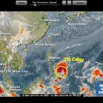
- March 22, 2014 Tropical Depression “Caloy” towards Camiguin Tropical depression “Caloy” has already made its landfall over Tandag City, Surigao del Sur and is moving towards Camiguin island, where […]


Recent Comments