Tropical Depression Quedan still hovering off Samar
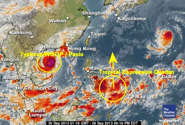
The Tropical Depression “Quedan” has slightly increased in strength as the pressure went down to 1002 hPa. “Quedan” is still hovering off Samar but seems to move very slowly northwards.
At 04:00 a.m. today, the center of Tropical Depression “Quedan” was estimated at 910 km East of Borongan, Eastern Samar (12.0°N, 134.8°E) with maximum sustained winds of 55 km/h near the center.
“Quedan” is enhancing the southwest monsoon (Habagat). Palawan, the Visayas and Mindanao will have cloudy skies with light to moderate rain showers and thunderstorms.
We keep an eye on Tropical Depression “Quedan”. For more and near real-time information see here:
Old Weather Page 
New Weather Page
New Marine Weather Page
Related posts
 March 26, 2014 Agus VI is leaking – electricity production drops A leak has developed in the Agus VI hydroelectric power plant intake in Maria Cristina Falls in Iligan City. Since last February 27, […]
- September 24, 2016 Strongest Earthquake this year 40 kilometres south of Mati This year's Strongest Earthquake hit the region of Mati in south-eastern Mindanao. A series of aftershocks is still rocking Davao […]
- August 1, 2019 Our House Dragons had a Family Meeting today Our House Dragons are of the species Varanus cumingi. They are also known as Monitor Lizards. Currently we have a gang of 3 of these guys […]
- February 8, 2021 Travel Advices for the Philippines – international and domestic Travel Advices for the Philippines in a compact form. Every day new information appear in the press and on websites. We try to give you a […]
- August 15, 2016 Pupuce – the story of a girl who is looking ahead – Alaska Pupuce had been there! The Swiss newspaper "24 heures" launched a series of 7 expedition to discover the effects of Global Warming […]


Recent Comments