Two Tropical Storms
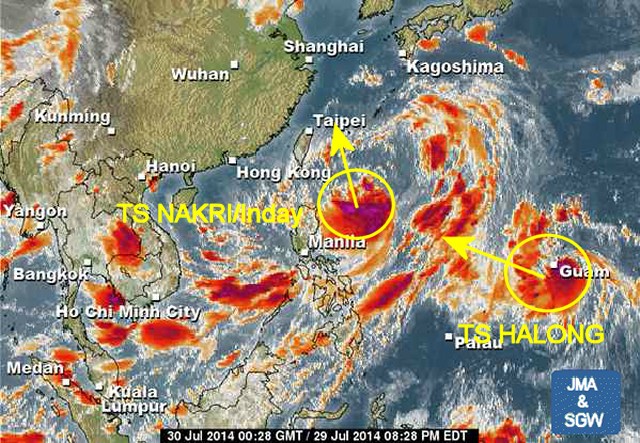
Two Tropical Storms are currently dominating the north-west Pacific. TS NAKRI/Inday is now north-east of northern Luzon and moves north-northwest. TS HALONG is in the vicinity of Guam and moves west-northwest.
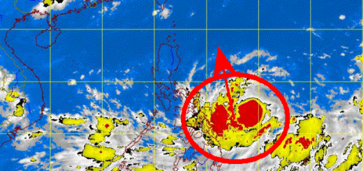
Storm Data TS NAKRI/Inday
| Name (INTL. / local): | NAKRI/Inday |
| Class: | Tropical Storm |
| Time/Date of observation: | 08:00 AM on July 30, 2014 |
| Location of Center: | 19.5° North 129.5° East |
| Moving Direction and Speed: | North @ 10 km/h |
| Moving towards: | Taiwan / China |
| Distance from the Philippines: | 800 km ENE of Aparri |
| Estimated Date / Time of Landfall: | n/a |
| Max. Wind Speed near Center: | 64 km/h |
| Peak Wind Gusts: | 92 km/h |
| Minimum Central Pressure: | 994 hPa |
| Diameter: | n/a |
| 24h Rainfall near Center: | n/a |
| Max. Wave Height: | 4 – 6 m |
| Here you find how to read and understand this data | |
Nearly real-time storm information
[GARD]
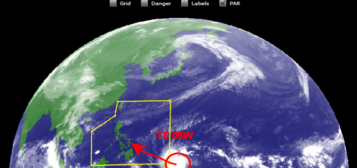
Storm Data TS HALONG
| Name (INTL. / local): | HALONG |
| Class: | Tropical Storm |
| Time/Date of observation: | 08:00 AM on July 30, 2014 |
| Location of Center: | 13.8° North 145.8° East |
| Moving Direction and Speed: | West-Northwest @ 15 km/h |
| Moving towards: | Northern Luzon |
| Distance from the Philippines: | 2300 km E of Virac |
| Estimated Date / Time of Landfall: | n/a |
| Max. Wind Speed near Center: | 83 km/h |
| Peak Wind Gusts: | 120 km/h |
| Minimum Central Pressure: | 992 hPa |
| Diameter: | n/a |
| 24h Rainfall near Center: | n/a |
| Max. Wave Height: | 8 – 10 m |
| Here you find how to read and understand this data | |
Nearly real-time storm information
[GARD]
Related posts
 November 18, 2015 Tropical Storm IN-FA moving west Tropical Storm IN-FA is moving west. This storm is still far away from the Philippines but has the potential to amplify to a Typhoon Cat. […]
- July 8, 2015 CHAN-HOM and NANGKA – Habagat Amplifiers Last weekend, Tropical Storm LINFA/Egay brought a lot of rain over northern Luzon. Now it is enhancing the southwest monsoon (Habagat) […]
- May 10, 2015 Tropical Storm DOLPHIN – The next bad guy? You may remember our storm report from May 8. We then reported a strange guy developing around Palikir, Micronesia. This strange guy now […]
- March 17, 2015 Tropical Storm BAVI plays tricks Tropical Storm BAVI plays tricks with observers and forecasters. The storm slowed down its forward speed to 25 km/h. The track direction […]
- January 18, 2015 Tropical Storm MEKKHALA/Amang now over Naga City Tropical Storm MEKKHALA/Amang now over Naga City. After having made landfall on Samar's east coast the storm lost some power. It still […]


Recent Comments