Geography
Volcanoes, Earthquakes, Maps and more
Volcanoes 
There are 37 volcanoes in the Philippines, of which 22 are still active volcanoes. In the last 10 years Mount Mayon, Mount Bulusan and Taal showed permanent activity. While Taal is slightly boiling and trembling, Mayon and Bulusan erupted repeatedly. See the locations and activity monitors of these volcanoes.
Active Volcanoes | 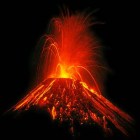 |
Volcanism is an extremely dynamic process. The PHIVOLCS "Volcano Bulletins" contain a lot of interesting background information, but they are like photos. They show just one moment. So we started in 2010 to collect the PHIVOLCS information about active volcanoes and put it into charts.
Earthquakes 
The Philippines are within the "Pacific Ring of Fire". Three tectonic plates meet in the Philippines' underground. The movements of these 3 tectonic plates are the reason for the very frequent earthquakes in the Philippines. We count 3 to 4 earthquakes per day. Most of them are weak and nobody feels them.
Maps 
Only ten years ago it had been difficult to find reliable maps of the Philippines. Today many maps are on-line on the Internet and are even available on smartphones. We link the best maps and provide thematic maps with multiple overlays. We support "OpenStreetMap" with our GPS devices.