Typhoon MELOR/Nona moving towards Samar-Sorsogon

Typhoon MELOR/Nona has been upgraded to Category 4 and is moving towards Samar-Sorsogon. The cyclone is now getting a bit weaker. The central pressure has slightly increased in the last 6 hours from 940 to 945 hPa.
CAUTION: Strong winds (up to 140 km/h), heavy rainfall (up to 500 mm) and a storm surge on the east coast of 1 to 6 meters are expected.
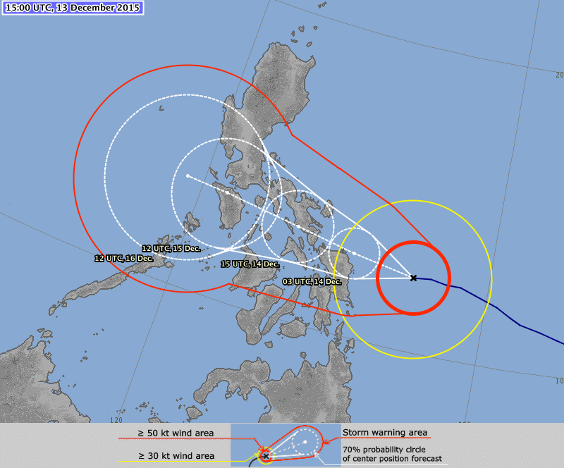
The region of landfall is still difficult to determine. Hongkong and Beijing agencies expect the northern tip of Samar. USA and Japan forecast a landfall in Sorsogon around Gubat. The time of landfall is expected between 11 a.m. and 2 p.m. today.
PAGASA Storm Signals:
Signal #3:
Catanduanes, Sorsogon, Albay and Ticao Island
Northern Samar, Eastern Samar and Samar
Signal #2:
Masbate including Burias Island, Camarines Sur, Camarines Norte, Marinduque, Romblon, Southern Quezon
Leyte and Biliran
Signal #1:
Oriental Mindoro, Batangas, Laguna, Rest of Quezon
Southern Leyte, Northern Cebu including Bantayan and Camotes Islands, Aklan, Capiz, Northern Negros Occidental
Dinagat province and Siargao Island
MELOR/Nona Storm data:
| Name (INTL. / local): | MELOR/Nona |
| Class: | Typhoon Cat. 4 |
| Time/Date of observation: | 11:40 PM on December 13, 2015 |
| Location of Center: | 13.0º North 123.4º East |
| Moving Direction and Speed: | West @ 20 km/h |
| Moving towards: | Samar – Sorsogon |
| Distance from the Philippines: | 1018 km ESE of Guiuan, Samar |
| Estimated Date / Time of Landfall: | 2015-12-14 around noon |
| Max. Wind Speed near Center: | 157 km/h |
| Peak Wind Gusts: | 220 km/h |
| Minimum Central Pressure: | 945 hPa |
| Diameter: | 550 km |
| 24h Rainfall near Center: | 50- 500 mm |
| Max. Wave Height: | 1 – 6 m (storm surge) |
| Here you find how to read and understand this data | |
Nearly real-time storm information
[GARD]
Related posts
 December 12, 2015 Cyclone MELOR/Nona moving towards Bicol Cyclone MELOR/Nona is now a Tropical Storm moving towards Bicol region and is intensifying. The cyclone should arrive early Tuesday […]
- July 24, 2008 Tabing Dagat Tabing Dagat our Culinary Discovery
In the Philippines it is often difficult to find a good restaurant with original Filipino cuisine. […]
- December 16, 2011 News Ticker: Rainy and gray, that’s all Nothing special to report. It slightly rains from a uniform gray sky.
Landfall is postponed to 3:00 PM this afternoon. We now have a […]
- March 25, 2014 Air Asia – Zest cease Cagayan de Oro operations It seems that the clean-up in the Philippines sky is progressing faster than expected. During the last weeks all domestic airlines […]
- September 17, 2014 Mayon volcano a dangerous Beauty Yesterday we reported that Alert Level 3 had been proclaimed for Mayon volcano. As of midnight Tuesday, 1,653 families had been evacuated […]


Recent Comments