
The Pope’s Depression
The Pope’s Depression is approaching Samar. The Tropical Depression 01W will intensify and arrive in Samar when the Pope will visit Leyte. Currently the TD is about 1,565 km east of Siargao Island. The Pope’s Depression...
The Pope’s Depression is approaching Samar. The Tropical Depression 01W will intensify and arrive in Samar when the Pope will visit Leyte. Currently the TD is about 1,565 km east of Siargao Island. The Pope’s Depression...
A new Tropical Depression (LPA 98W) is forming east of Palau. The TD is slowly moving westwards, towards the Philippines. Weather is still sunny in the Philippines. There are some locally produced cumulus clouds...
PEIPAH/Domeng – no useful forecast available. The depression/storm is playing tricks with forecasters while it has entered PAR (Philippines Area of Responsibility). Why is forecast so difficult? Weather forecast is based on two processes....
The Tropical Depression (TD 05W ) still east of Palau moving west to northwest towards the Philippines. The forward speed is about 15 km/h. The wind speeds are 55 km/h near the center with gusts...
There is a Tropical Depression (TD 05W ) east of Palau moving westwards. This tropical Depression is currently far in the south at about 2° north and moves at 11 km/h. In the following...
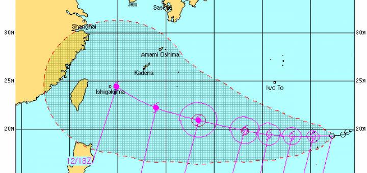
Tropical Depression “1331 / Zoraida” seems to stay more south. Latest JMA forecast tracks show that the TD will make landfall tomorrow morning in the south-eastern parts of Mindanao near Davao. Other agencies maintain...
The new Tropical Depression “1331 / Zoraida” got a bit weaker today. The pressure raised from 1000 to 1002 hPa. Forecast for tomorrow is 996 hPa. TD “1331 / Zoraida” is expected to accelerate northwestward...
The Low pressure Area (LPA) o7W is already a Tropical Depression TD and is quickly increasing in strength. JMA and US Navy forecast typhoon strength within 2 days. The new TD should cross 20°...
Tropical Depression 99W / Gorio becomes better organized over the Philippine Sea, east of Surigao Del Norte. It is likely to strengthen within the next 6 to 12 hours. Its center was located about 350 km...
Two days ago a Low Pressure Area (LPA) started to hover east of Mindanao. It did nearly not move but its pressure decreased from 1010 hPa to 1004 hPa. Still remaining some 500 km...
Tropical Depression 94W /Fabian has moved north to northeast during the past 6 hours while over the West Philippine Sea with no change in strength. Tropical Depression 94W / Fabian is expected to move out...
Tropical depression “Emong” has maintained its strength as it moves north northwest with maximum sustained winds of 55 km/h near the center. It is forecast to move north northwest at 15 km/h. Meanwhile, the...
The Low Pressure Area (LPA) estimated East of Surigao City has developed into a Tropical Depression and was named “EMONG”. The transformation of The Low Pressure Area into a significant Tropical Cyclone is possible over...
Floating northwards over the warm waters of the Philippine Sea the tropical depression 98W / Dante has powered up. It’s core pressure is now 1004 hPa. The Japan Meterological Agency (JMA) has analyzed this...
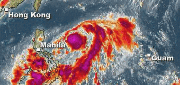
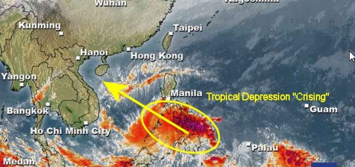
The Tropical Depression “CRISING” is moving west-northwest at 15 km/h. Palawan risks heavy rains today. The situation in northern Mindanao is still critical. Flights from and to Cagayan de Oro are cancelled. At this...
The Tropical Depression “CRISING” is still moving northwest at 22 km/h. Now also the Central Visayas are getting rain and Palawan risks heavy rains tonight and tomorrow morning. The situation in Mindanao has calmed...
The Tropical Depression “CRISING” is moving west to northwest at 22 km/h. The biggest quantity of rain went down in northern Mindanao, Camiguin and Bohol (violet color in the map below). The center...

Need to relax?
Stay at our Camiguin Beach Guesthouse. You are only one click away from vacation:


Recent Comments