TS PEIPAH: Forecasts are converging
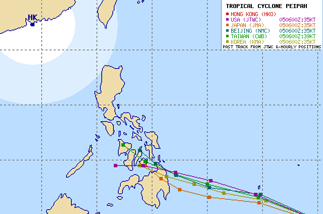
The forecasts for Tropical Storm PEIPAH are narrowing. The multi-agency forecasts now converge 0ver Misamis Oriental, Camiguin, Surigao del Norte and Bohol.
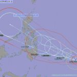
The storm is still accelerating closer to Palau and is expected to enter the Philippine Area of Responsibility (PAR) tomorrow Sunday. Tropical Storm PEIPAH is expected to continue moving generally west to northwest with a slight to gradual decrease in its forward speed. However, TS PEIPAH could become a severe Tropical Storm by Monday afternoon.
PAGASA still does not publish warnings. As the storm is outside PAR, the Philippine Area of Responsibility, PAGASA feels not responsible to inform people here. Now, we still have 3+ days to prepare. Tomorrow precious 24 hours will be lost. Why does PAGASA not recommend to observe weather? Maybe, because it’s still sunny out of their office.
| Name (INTL. / local): | PEIPAH |
| Class: | Tropical Storm |
| Time/Date of observation: | 05:00 PM (PST) on April 05, 2014 |
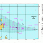
| Location of Center: | 5.2º North 138.5º East |
| Moving Direction and Speed: | WNW @ 22 km/h = 13 mph |
| Moving towards: | Palau |
| Distance from the Philippines: | 1,300 km from Mindanao |
| Estimated Date / Time of Landfall: | Morning of April 9, 2014 |
| Max. Wind Speed near Center: | 65 km/h = 35 kt |
| Peak Wind Gusts: | 85 km/h = 50 kt |
| Minimum Central Pressure: | 996 hPa |
| Diameter: | 665 km = 360 NM |
| 24h Rainfall near Center: | n/a |
| Max. Wave Height: | 6 m = 19 ft |
| Here you find how to read and understand this data | |
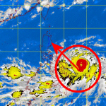
The 24 hours animated satellite loops are here.
[GARD]
Related posts
 December 3, 2014 Typhoon HAGUPIT/Ruby – again Samar? Typhoon HAGUPIT/Ruby has been upgraded to a Typhoon Category 2. It heads now rather towards Samar and maintains its western movement. […]
- December 13, 2011 Tropical Depression 27W approaching Tropical Depression 27W is approaching.
Tropical Depression 27W moves unusually low-south and directs to northern Minadanao and […]
- January 20, 2014 North-East Mindanao flooded It rained all day on our little lovely island of Camiguin. Camiguin lays some 15 km north of Mindanao. We wondered how the weather was […]
- July 9, 2013 Severe water pollution in Benoni port Yesterday vendors in the Port of Benoni, Camiguin sighted an oil spill at the vicinity and immediately reported the incident to the Coast […]
- September 23, 2012 “JELAWAT / Lawin” upgraded to Typhoon Cat.1 Severe Tropical Storm “JELAWAT / Lawin” has again intensified and is now a Typhoon Cat. 1.
“JELAWAT / Lawin” has also changed its […]


Recent Comments