PEIPAH/Domeng – nobody knows
PEIPAH/Domeng – no useful forecast available. The depression/storm is playing tricks with forecasters while it has entered PAR (Philippines Area of Responsibility).
Why is forecast so difficult?
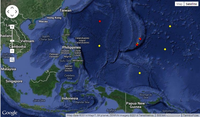
Weather forecast is based on two processes. First comes the observation and measurement of the current state of the atmosphere. There are hundreds of weather stations all over the Philippines, but there are only very few observations over the vast waters of the Pacific. Only 4 permanent weather stations are on the main route of most tropical storms: Guam (13.40N – 144.80E), Siapan (15.10N – 145.50E), Majuro (7.30N – 171.30E) and Wake (19.50N – 166.50E).
Yellow means recent weather data, red means no data within the last 8 hours.
The second source of information are the satellite images. Satellites like MTSAT-2 gather data with different sensors. These sensors can measure in five wavelength bands, one visible and four infrared. They measure density of water vapor (clouds), atmospheric temperature and sea surface temperature. With this data computer programs (models) and human analysts try to predict what will happen in the near future.
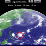
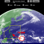
Interpreting this satellite data is easy when there is a closed, concentrated storm system without external disturbance. As soon as the system opens or is under the influence of another system, the forecast becomes cumbersome. Compare the two pictures below. They were taken recently and 24 hours ago.

24 hours ago, the center of PEIPAH/Domeng had been easy to detect
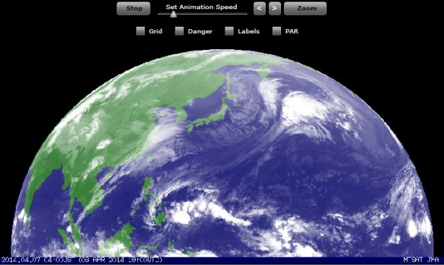
Now it is much more difficult to determine a center and its movement.
The 24 hours animated satellite loops are here.
What now?
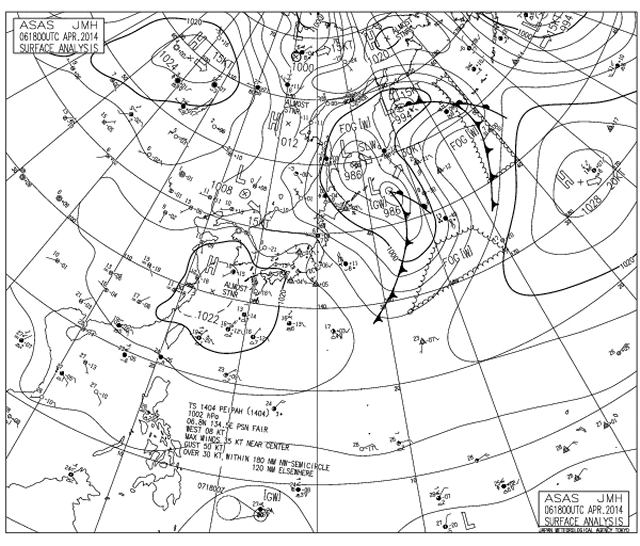
We follow the development of the atmosphere. The best source available is the isobar map of JMA.
[GARD]
Related posts
 January 14, 2015 The Pope’s Depression The Pope's Depression is approaching Samar. The Tropical Depression 01W will intensify and arrive in Samar when the Pope will visit Leyte. […]
- July 12, 2014 First Typhoon 2014 First Typhoon 2014. After Super-Typhoon NEOGURI passed by and hit Okinawa and south-western Japan, RAMMASUN will probably hit the northern […]
- April 20, 2014 New Tropical Depression forming A new Tropical Depression (LPA 98W) is forming east of Palau. The TD is slowly moving westwards, towards the Philippines.
Weather is […]
- April 5, 2014 Tropical Storm 05W The Tropical Depression 05W has strengthened into a Tropical Storm and has accelerated its west-northwest movement towards Palau.
This […]
- April 4, 2014 Tropical Depression changes direction The Tropical Depression (TD 05W ) still east of Palau moving west to northwest towards the Philippines.
The forward speed is about 15 […]


Recent Comments