Tropical Storm BAVI weakens

Tropical Storm BAVI weakens while maintaining its westward track towards the Philippines – heading for Luzon. Tropical Storm BAVI is expected to enter PAR on Tuesday afternoon.
Good News
Tropical Storm BAVI is weakening. From today’s 994 hPa central pressure it will increase to 1000 hPa on Wednesday. The storm then might be downgraded to Tropical Depression. The depression might make landfall on Thursday.
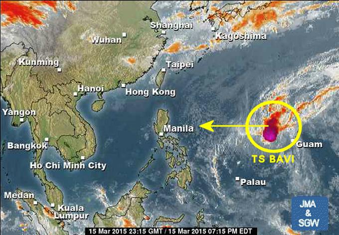
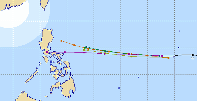
During the last 24 hours satellite observations made us even hope that the storm might turn northwards. Rather weak High Pressure Areas over southern China and Japan prevent this movement. The track forecasts of the different agencies are uniform. Only in the final approach to Luzon they spread from northern Bicol up to Aurora.
Storm data:
| Name (INTL. / local): | BAVI |
| Class: | Tropical Storm |
| Time/Date of observation: | 5:00 a.m. on March 16, 2015 |
| Location of Center: | 12.9º North 142.6º East |
| Moving Direction and Speed: | West @ 35 km/h |
| Moving towards: | Northern Philippines |
| Distance from the Philippines: | 1,800 km |
| Estimated Date / Time of Landfall: | n/a |
| Max. Wind Speed near Center: | 74 km/h |
| Peak Wind Gusts: | 111 km/h |
| Minimum Central Pressure: | 994 hPa |
| Diameter: | n/a |
| 24h Rainfall near Center: | n/a |
| Max. Wave Height: | n/a |
| Here you find how to read and understand this data | |
We keep an eye on this storm. Next update as soon as we get new data.
[GARD]
Related posts
 March 14, 2015 Tropical Storm BAVI still approaching Tropical Storm BAVI is still moving west. The storm has accelerated its forward speed to 35 km/h. This storm does not yet affect the […]
- March 13, 2015 Tropical Storm BAVI moving west Tropical Storm BAVI is moving west to northwest at 30 km/h. This storm does not yet affect the Philippines as it is some 3,700 kilometers […]
- January 2, 2013 Depression – what depression – tropical depression The Low Pressure Area (LPA) 92W is now a Tropical Depression.
Here in Camiguin we had strong rains all the day and they continue.
There […]
- September 27, 2014 A Saturday morning dive with Arno It's nice to have a neighbor who is a dive instructor and a professional photographer. This morning Arno asked me if I would like to go […]
- May 8, 2012 Terminal fee – I can’t believe it Over years I had railed against this silly terminal fee in the Philippines. Anywhere in the world all the airport taxes are included in […]


Recent Comments