Ouverture furioso – Super Typhoon NEPARTAK / Butchoy

The 2016 Typhoon Season starts with a Super Typhoon. Typhoon NEPARTAK / Butchoy has rapidly gained strength and is now a Super Typhoon Cat. 4. Tue United Nations have issued a Red Typhoon Alert for Taiwan and southern China.
Last night Typhoon NEPARTAK has entered the Philippines Area of Responisibility (PAR). As usual it got a local name. It is called Butchoy in the Philippines.
Typhoon NEPARTAK / Butchoy Track
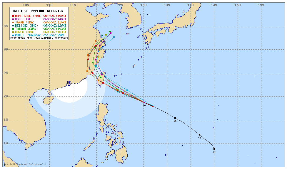 Map courtesy of Typhoon2000.ph
Taiwan will encounter a black Friday. The storm is running towards Taiwan with a speed of 35 km/h (18 kts).
NEPARTAK / Butchoy Storm data:
| Name (INTL. / local): | NEPARTAK / Butchoy |
| Class: | Super Typhoon Cat.4 |
| Time/Date of observation: | 05:40 AM on July 06, 2016 |
| Location of Center: | 18.3º North 131.0º East |
| Moving Direction and Speed: | West- Northwest @ 35 km/h |
| Moving towards: | Taiwan |
| Distance from the Philippines: | 961 km ENE of Casiguran |
| Estimated Date / Time of Landfall: | Friday morning |
| Max. Wind Speed near Center: | 220 km/h |
| Peak Wind Gusts: | 280 km/h |
| Minimum Central Pressure: | 914 hPa |
| Diameter: | 500 km |
| 24h Rainfall near Center: | 50 – 150 mm |
| Max. Wave Height: | 10 – 12 m |
| Here you find how to read and understand this data | |
Nearly real-time storm information
[GARD]
Related posts
 July 6, 2016 Super Typhoon NEPARTAK / Butchoy now Category 5 The first Typhoon of the Storm Season 2016 is a real Monster. Approaching the costs of Taiwan it now presents gust wind speeds of up to […]
- July 5, 2016 Typhoon Nepartak moving fast west-northwest towards Taiwan Typhoon Nepartak has been upgraded from a Tropical Storm to a Typhoon Cat.1. It is moving fast at 30 km/h towards Taiwan. Only the most […]
- July 21, 2014 Typhoon MATMO/Henry’s backdoor Typhoon MATMO/Henry seems to pass by. But even if it is not hitting the Philippine islands it is amplifying the south-west monsoon called […]
- July 18, 2014 Tropical Storm MATMO/Henry Tropical Storm MATMO/Henry has intensified as it entered PAR. Tropical Storm MATMO/Henry is expected to continue moving slowly […]
- September 2, 2013 Landslide – what landslide? It’s sunny in the Philippines People ask me often about our landslide warnings. Most tourists cannot imagine what it means. Landslide? What is sliding?
Our northern […]


Recent Comments