Tropical Depression Bising brings ugly weather

Tropical Depression Bising is approaching the Philippines.
The Tropical Depression Bising is approaching Surigao (eastern Mindanao) at a speed of 10 to 13 km/h. Wind-speed is estimated at 45 km/h (PAGASA) or 65 km/h (JMA). Gusts can reach speeds of up to 90 km/h. The pressure decreased today to 1,000 hPa. Wave heights of 2 to 4 meters are expected on the Philippines’ east coast. While JMA has not yet calculated a probable track forecast, PAGASA has published a map with their first severe weather warning.
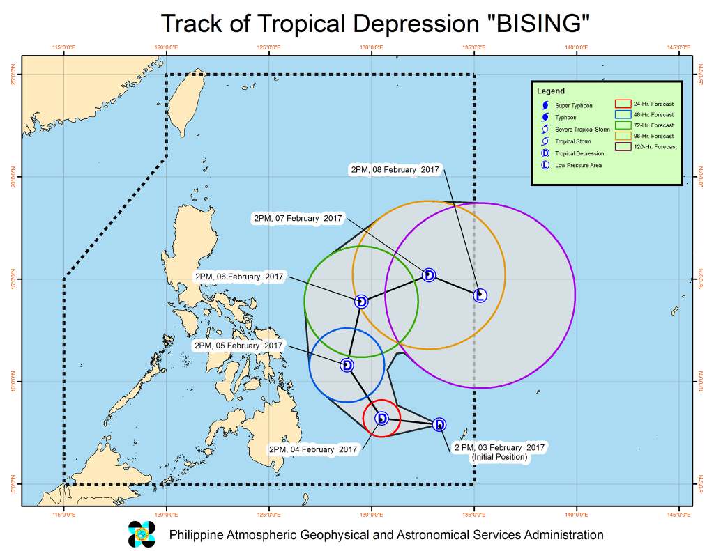
Tropical Depression Bising – Track Forecast
THE LOW PRESSURE AREA EAST OF MINDANAO HAS DEVELOPED INTO A TROPICAL DEPRESSION AND WAS NAMED “BISING.”
• Estimated rainfall amount is from moderate to occasionally heavy rains within the 300 km diameter of tropical depression.
• Sea travel is risky over the Northern and Eastern Seaboards of Luzon and the Eastern Seaboard of Visayas.
Location of eye/center: At 4:00 PM today, the center of Tropical Depression “BISING” was estimated based on all available data at 735 km East of Hinatuan, Surigao del Sur (8.0°N, 133.0°E).
Strength: Maximum winds of up to 45 kph near the center and gustiness of up to 55 kph.
Forecast Movement: Forecast to move West Northwest at 13 kph.
Forecast Positions:
• 24 Hour( Tomorrow afternoon): 460 km East of Hinatuan, Surigao del Sur (8.2°N, 130.5°E)
• 48 Hour(Sunday afternoon):340 km East of Guiuan, Eastern Samar (10.8°N, 128.8°E)
• 72 Hour(Monday afternoon): 510 km East Northeast of Borongan City, Eastern Samar (13.9°N, 129.5°E)
• 96 Hour(Tuesday afternoon):895 km East Northeast of Borongan City, Eastern Samar (15.2°N, 132.8°E)
• 120 Hour(Wednesday afternoon):1,100 km East Northeast of Guiuan, Eastern Samar (OUTSIDE PAR) (14.2°N, 135.3°E)
Danger
The Tropical Depression Bising increases the risk of landslides and flashfloods along the eastern islands. The soils are still soaked by the past rains. Be careful and avoid rivers and hill slopes.
[GARD]
Related posts
 March 29, 2015 Typhoon MAYSAK Cyclone MAYSAK has gained strength and is now a Typhoon Cat. 1. Typhoon MAYSAK is still heading west-northwest towards the Philippines. […]
- May 16, 2012 The tensions between China and the Philippines get uncomfortable The tensions between China and the Philippines get uncomfortable. China last week issued a travel safety alert for the Philippines.
1. […]
- June 8, 2013 Nomen est Omen The Philippines and Dante - seems to be a love/hate relationship!
Not a month ago, Francis Tolentino, chairman of Metro Manila […]
- November 14, 2011 Nasty weather ahead The Tropical Disturbance LPA 91W has reached the Philippines.
As the disturbance moves very slowly north-westwards it will bring rain in […]
- December 20, 2014 Philippines Airspace News Philippines Airspace News - the pope's visit creates more turbulence than expected and Cebu Mactan's airport extension already stalls. And […]


Recent Comments