Tropical Storm NURI / Paeng
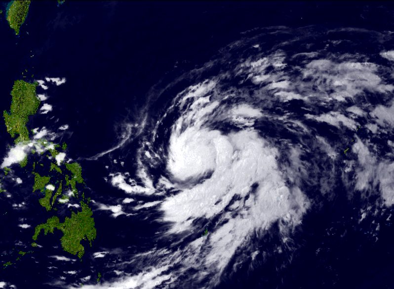
Tropical Storm NURI / Paeng is getting stronger. The storm is now within PAR and moving west to northwest. In the next 24 hours Tropical Storm NURI / Paeng will increase in strength and move more northwards.
Early tomorrow, Sunday, morning Tropical Storm NURI / Paeng will become a typhoon. The storm will continue to increase in strength when moving north.
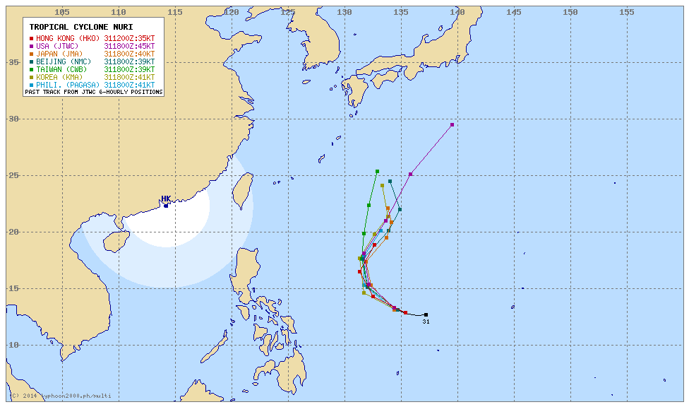
Multi-Ageny map courtesy of typhoon2000.ph
This storm system will influence the weather in the Philippines in the coming days. Although the storm will not cross over the Philippine Islands, it will bring cloudy condition, sometimes gusty winds and scattered rains.
NURI/Paeng Storm data:
| Name (INTL. / local): | NURI / Paeng |
| Class: | Tropical Storm |
| Time/Date of observation: | 05:40 AM on November 1, 2014 |
| Location of Center: | 13.1º North 134.1º East |
| Moving Direction and Speed: | West-Northwest @ 15 km/h |
| Moving towards: | North Luzon |
| Distance from the Philippines: | 1440 km E of Manila |
| Estimated Date / Time of Landfall: | n/a |
| Max. Wind Speed near Center: | 72 km/h |
| Peak Wind Gusts: | 108 km/h |
| Minimum Central Pressure: | 992 hPa |
| Diameter: | n/a |
| 24h Rainfall near Center: | n/a |
| Max. Wave Height: | 6 m |
| Here you find how to read and understand this data | |
Nearly real-time storm information
[GARD]
We keep an eye on this storm and will inform twice daily around 8 a.m. and 8 p.m. (Philippines Standard Time).
Related posts
 November 1, 2014 Severe Tropical Storm NURI / Paeng Severe Tropical Storm NURI / Paeng is intensifying rapidly while turning northwest to north. The satellite clearly show the begin of the […]
- April 5, 2014 Tropical Storm 05W The Tropical Depression 05W has strengthened into a Tropical Storm and has accelerated its west-northwest movement towards Palau.
This […]
- September 29, 2014 Cebu Pacific Air – too much capacity? Cebu Pacific Air has capacity problems in two ways. On the one hand they put world's biggest number of seats in their Airbus A300-300. And […]
- December 16, 2011 Tropical Storm WASHI / Sendong has made landfall Tropical Storm WASHI / Sendong had made landfall already around 2:30 PM near Baganga, Davao Oriental. The storm continues on its western […]
- September 8, 2011 PTA becomes TIEZA The Philippine Tourism Authority (PTA) has changed its name into Tourism Infrastructure and Enterprise Zone Authority (TIEZA).
This […]


Recent Comments