3 ugly guys around here – Tropical Storms everywhere
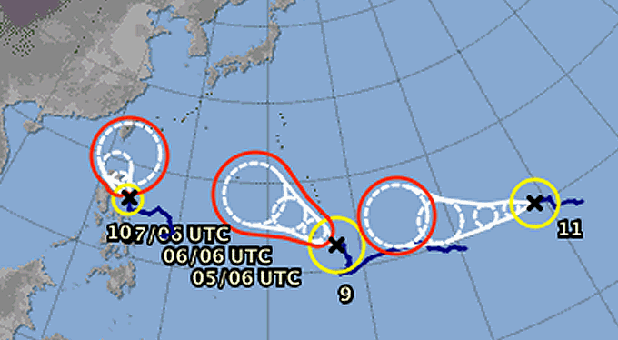
3 less or more strong storms are currently whirling over the North-West Pacific. Nearest one is Tropical Storm LINFA/Egay, moving late tomorrow or early Monday morning over most northern Luzon and the Batanes Group of Islands.
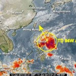
Tropical Storm LINFA/Egay is hovering around over the Western-Central Philippine Sea and is moving northwest at 11 km/h. IMA predicts an increased strength, so the storm may become a Severe Tropical Storm before reaching the Philippines coast.
More to the east Tropical Storm CHAN-HOM is strengtening in should become a typhoon cat.1 tonight. This cyclone should not become a threat for the Philipines. Currently it is still unstable, but once it will be organized it will quickly move on a north-western track and move towards Okinawa.

The 3rd cyclone is still far away. Tropical Storm NANGKA is around 170° East and 10° North. Its current position does not fit in the standard map. It also has the potential to become a typhoon but it isn’t to expect that it will reach the Philippines.
We observe the development of these three low pressure systems and will inform you about any critical change. Meanwhile you want to have a look yourself on our permanent satellite movies.
[GARD]
Related posts
 July 16, 2014 Typhoon RAMMASUN/Glenda out in the sea Typhoon RAMMASUN/Glenda has left the Philippine islands. It lost a lot of strength and is now off the coast of Bataan. Rainfall around […]
- November 19, 2011 New terminal fees in Cebu Mactan This November 1, the airport authority of Cebu Mactan (CEB) has introduced new terminal fees.
International departure: 550 PHP
[…]
- January 12, 2013 Tropical Depression “Bising” now moving towards Bicol region Storm signal N°1 was raised in parts of Luzon and Visayas as low pressure area located east of Surigao City intensified into tropical […]
- March 9, 2012 Already 333 Earthquakes since January 1st, 2012 The underground in the Philippines is moving. There are currently 4 regions that experience nearly daily earthquakes: Negros, Mindoro, […]
- November 19, 2015 Cyclone IN-FA | short update Cyclone IN-FA has gained strength and is now a Typhoon Category 1. Fortunately the track of this storm has already started to veer to […]


Recent Comments