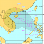
CHAN-HOM and NANGKA – Habagat Amplifiers
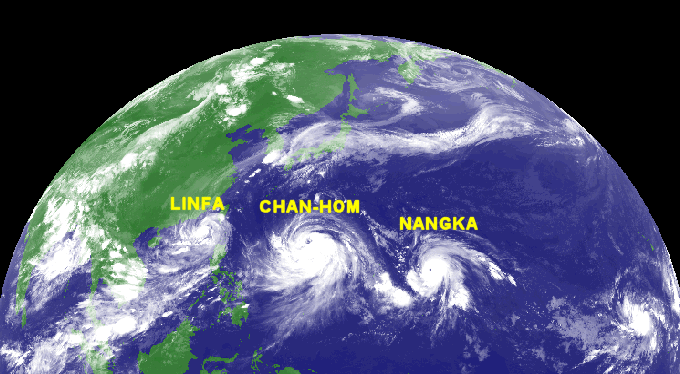
Last weekend, Tropical Storm LINFA/Egay brought a lot of rain over northern Luzon. Now it is enhancing the southwest monsoon (Habagat) together with the 2 Typhoons CHAN-HOM (Cat.1) and NANGKA (Cat.4).

Animated satellite pictures are here.
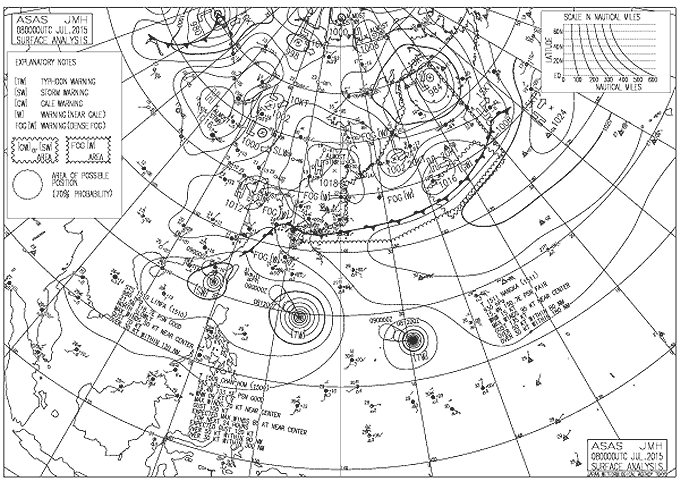
Tropical cyclones act as extremely powerful atmospheric pumps. Their suction can pump air over several hundred miles (yellow arrows).
Habagat
The red arrow shows Habagt air-flow. This seasonal monsoon is caused by warm air over mainland Asia. Hot air is lighter than cold air. This why hot air flows upwards (hot air balloon) and leaves a low pressure on the ground. This low pressure attracts the air from southwest.
The Habagat season is characterized by hot and humid weather, frequent heavy rainfall, and a prevailing wind from southwest to west. Habagat is also known as monsoon or southwest monsoon in the Philippines. The main indicator of the switch between the Amihan and Habagat seasonal patterns is the switch in wind direction.
IMPORTANT:
Typhoon CHAN-HOM will not directly hit the Philippines, but by it’s size 980 km it will bring clouds and probably rain to the northern Philippines. Typhoon NANGKA will not affect the Philippines as it is turning north – towards Japan.
The northern Philippines will remain rainy and cloudy while the south is rather sunny with scattered clouds. The southern islands are exposed to the constant eastern north equatorial wind flow (Easterlies) and the southwestern Habagat. Weather forecast is very difficult. The collision zone of the two air streams changes its location very often and very quickly .
[GARD]
Related posts
 November 18, 2015 Tropical Storm IN-FA moving west Tropical Storm IN-FA is moving west. This storm is still far away from the Philippines but has the potential to amplify to a Typhoon Cat. […]
- August 10, 2013 Tropical Storm UTOR / Labuyo getting stronger During last night Tropical Depression 11W / Labuyo has strengthened and is now a Tropical Storm called UTOR / Labuyo. It continues to move […]
- July 8, 2013 Tropical Storm SOULIK/07W is getting stronger and bigger The strong Tropical Depression (TD) north of Guam has strengthened into a Tropical Storm SOULIK/07W. It is now passing very close to the […]
- May 27, 2012 Summer is over! Habagat replaces Amihan During the last weeks we encountered what local people call the father of all winds. The north-east winds, known as Amihan steadily got […]
- October 12, 2011 Tropical Storm BANYAN / Ramon – update 12:00 PM 10/12/2011 Tropical Storm BANYAN / Ramon has rapidly accelerated & was relocated farther to the West.It is now in the vicinity of Cebu Island. […]


Recent Comments