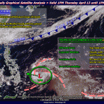
Tropical Depression “Bising” now moving towards Bicol region
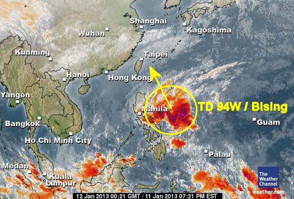
Storm signal N°1 was raised in parts of Luzon and Visayas as low pressure area located east of Surigao City intensified into tropical depression “Bising,” the PAGASA informed Friday night.
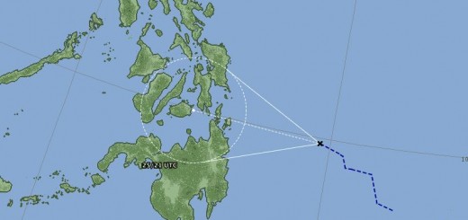
The tropical Depression Bising / 94W is now moving towards the Bicol region. Its general moving direction is north-northwest. The winds aren’t strong and should not damage anything. But rain is heavy with up to 250 mm in 24 hours. There is a real danger of flashfloods and landslides.
Storm data:
| Name (INTL. / local): | LPA-94W/Bising |
| Class: | Tropical Depression |
| Time/Date of observation: | 05:00 PM on January 12, 2013 |
| Location of Center: | 13.7º North 126.2º East |
| Moving Direction and Speed: | NNW @ 22 km/h = 12 mph |
| Moving towards: | parallel Bicol region |
| Distance from the Philippines: | 206 km from Virac |
| Estimated Date / Time of Landfall: | n/a |
| Max. Wind Speed near Center: | 35 km/h |
| Peak Wind Gusts: | 55 km/h |
| Minimum Central Pressure: | 1006 hPa |
| Diameter: | n/a |
| 24h Rainfall near Center: | 250 mm |
| Max. Wave Height: | 3.5 m = 10 ft |
Here you find how to read and understand this data  |
|
Related posts
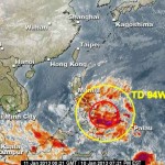
 January 11, 2013 Tropical Depression 94W unloads tons of water The Tropical Depression 94W slowly moves northward at 15 km/h. This morning at 06:00 AM its center was 297 km east of Bislig City […]
- February 19, 2013 Tropical Depression “CRISING” – Mindanao under Signal 1 The tropical depression south-east of Mindanao has intensified and accelerated. It was given the name "Crising". PAGASA put 18 provinces […]
- February 18, 2013 Rainy week ahead A Tropical Disturbance LPA 98W brings rainy weather to the south of the Philippines. After a sunny weekend it raining now since early […]
- November 12, 2012 Rains could trigger flashfloods and landslides today PAGASA warns in their 5:00 AM Weather Bulltin that the Visayas and Mindanao and the regions of MIMAROPA and Bicol will be cloudy with […]
- October 19, 2015 Typhoon KOPPU/Lando – Floods and Landslides Floods and Landslides haunt the northern provinces, especially Nueva Ecija. Typhoon KOPPU/Lando still dumps up to 133mm of rain per hour […]


Recent Comments