Typhoon RAMMASUN/Glenda out in the sea
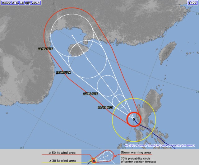
Typhoon RAMMASUN/Glenda has left the Philippine islands. It lost a lot of strength and is now off the coast of Bataan. Rainfall around Metro Manila got much weaker. Typhoon RAMMASUN/Glenda is now heading towards Hainan (China). Over the warm waters of the West-Philippine Sea it will again accumulate energy and get stronger.
The forecast of JMA (Japan Meteorological Agency) is as good as it always is.
Non of the Philippine weather agencies offers up to date weather reports. PAGASA’s last report is from 11:00 a.m. Typhoon2000 (Michel Padua) announced already last night that he fears to be off-line today. And Weather Philippines seem also to suffer from the power cuts around Manila, Laguna and Bicol.
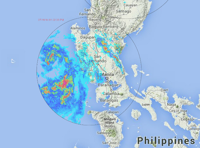
The best local source for weather information is now the DOST Project Noah. The 6 Doppler radar stations give an excellent real-time overview of current rainfall. The layer technology is outstanding. One can choose any layer and put it over the map. My sincere congratulations go to Icannhas.
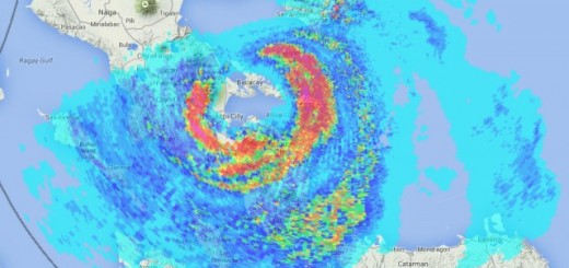
Rammasun/Glenda Storm data:
| Name (INTL. / local): | RAMMASUN / Glenda |
| Class: | Typhoon Cat. 2 |
| Time/Date of observation: | 14:30 PM on July 16, 2014 |
| Location of Center: | 14.5º North 119.8º East |
| Moving Direction and Speed: | West-Northwest @ 26 km/h |
| Moving towards: | Hainan (China) |
| Distance from the Philippines: | 117 km west of Manila |
| Estimated Date / Time of Landfall: | n/a |
| Max. Wind Speed near Center: | 150 km/h |
| Peak Wind Gusts: | 285 km/h |
| Minimum Central Pressure: | 955 hPa |
| Diameter: | 555 km (small) |
| 24h Rainfall near Center: | 200 – 300 mm |
| Max. Wave Height: | n/a |
| Here you find how to read and understand this data | |
Nearly real-time storm information
[GARD]
Related posts
 May 7, 2015 Typhoon NOUL/Dodong short update Typhoon NOUL/Dodong is developing now quiet fast. It is already a Cat.2 Typhoon at a central pressure of 956 hPa. Its forward speed has […]
- March 30, 2015 Typhoon MAYSAK – short update Typhoon MAYSAK is continuing on its westward track at 20 km/h. The current position is 8.8° North and 145.2° East. The cyclone has […]
- March 30, 2015 Typhoon MAYSAK now Category 2 Typhoon MAYSAK got stronger and is now a Typhoon Category 2. The cyclone is continuing its westward track towards the Philippines at a […]
- December 3, 2014 Typhoon HAGUPIT/Ruby – update 12/03-2 Typhoon HAGUPIT/Ruby forecast tracks are again heading more south. All agencies except US NAVY (JTWC) follow the JMA forecast. You may […]
- November 2, 2014 Typhoon NURI/Paeng – the Eye Typhoon NURI/Paeng is just now developing its eye. You can witness this genesis watching our 24 hours satellite loops. Typhoon NURI/Paeng […]


Recent Comments