Returning Typhoon BOPHA/Pablo is Category 3 now!
Typhoon BOPHA/Pablo again got stronger and is now a Typhoon Category 3.
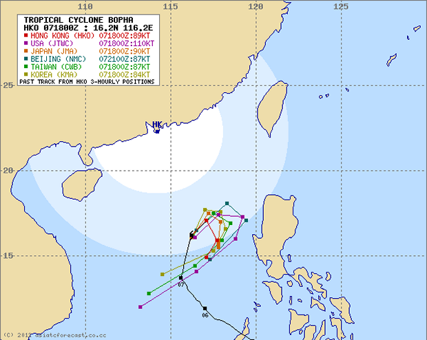
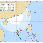
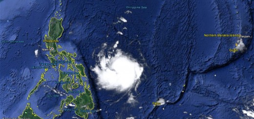
It is still hovering over the West Philippine Sea but has now turned north to north-east. The storm moves at 13 km/h.
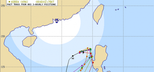
As of 06:00 AM this morning, the eye of Typhoon BOPHA/Pablo was located over the West Philippine Sea about 394 km west of San Fernando City, La Union or 400 km west-northwest of Dagupan City, Pangasinan.
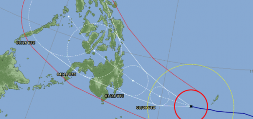
All multi-agency forecasts join now the “loop-forecast”. The development for Luzon now depends on the error margin of the models used.

JMA’s forecast now shows the north to north-east direction. be careful with this map projection: North is not straight up, but follows the converging meridians.
Storm data:
| Name (INTL. / local): | BOPHA/Pablo |
| Class: | Typhoon Category 3 |
| Time/Date of observation: | 06:00 PM on December 08, 2012 |
| Location of Center: | 15.6º North 116.6º East |
| Moving Direction and Speed: | NNE @ 13 km/h |
| Moving towards: | San Fernando, La Union |
| Distance from the Philippines: | 394 km West of San Fernando |
| Estimated Date / Time of Landfall: | ??? |
| Max. Wind Speed near Center: | 205 km/h |
| Peak Wind Gusts: | 250 km/h |
| Minimum Central Pressure: | 941 hPa |
| Diameter: | 555 km |
| 24h Rainfall near Center: | 500 mm This is extreme! |
| Max. Wave Height: | 13 m = 41 ft |
Here you find how to read and understand this data  |
|
Related posts
 December 8, 2012 Typhoon BOPHA/Pablo drives forecasters crazy – short update Typhoon BOPHA/Pablo is approaching northern Luzon. A final track cannot yet be seen. Track forecasts go from crossing Ilocos Norte to a […]
- December 8, 2012 Typhoon BOPHA/Pablo approaches Northern Luzon Typhoon BOPHA/Pablo is approaching northern Luzon. A final track cannot yet be seen. There are still too many parameters open for the […]
- December 8, 2012 Typhoon BOPHA/Pablo – the Movie We track the weather 7/24. if there is a dangerous situation, we inform our readers. One of our information sources is the Infrared (IR) […]
- December 7, 2012 Typhoon BOPHA/Pablo again got stronger – Category 2 now! Typhoon BOPHA/Pablo again got stronger and is again a Typhoon Cat.2.It is hovering over the West Philippine Sea. It's future direction […]
- December 7, 2012 Oh no, Cyclone BOPHA/Pablo seems to come back Cyclone BOPHA/Pablo is now a Severe Tropical Storm out in de West Philippine Sea. It has wind speeds of 95 to 120 km/h. This morning at 6 […]


Recent Comments