Typhoon BOPHA/Pablo approaches Northern Luzon
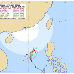
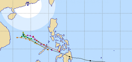
Typhoon BOPHA/Pablo is approaching northern Luzon. A final track cannot yet be seen. There are still too many parameters open for the final track. The typhoon might turn westwards still off-shore, but it might also hit northern Luzon.
People living in Ilocos Region down to La Union, Pangasinan, Benguet, and Zambales are warned that the typhoon might make landfall in their region.
The big problems of current forecasts are the sea-surface temperatures and the influence of the cool Amihan air-stream. The last 2 days proved that the water up north is still too warm and that Amihan does not cool down the air.
Friends in San Juan (La Union) reported an hour ago heavily covered skies, but no wind and no rain. Let’s hope! We keep them informed.
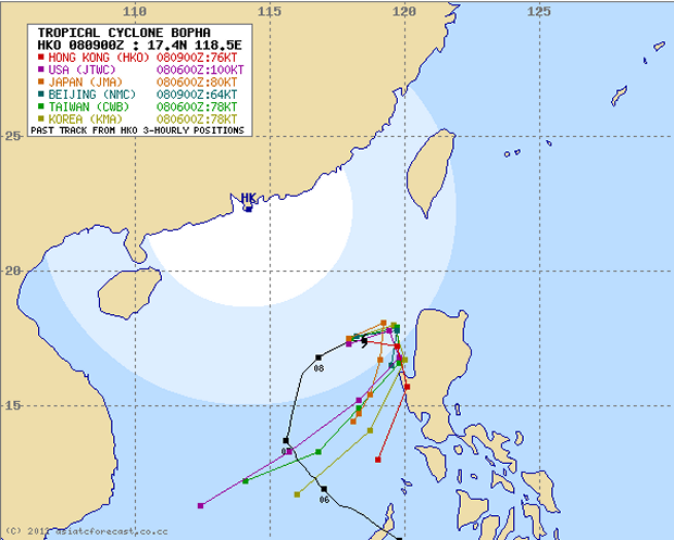
The multi-agency forecast gets near to northern Luzon. Will it be Illocos Norte? Will it be La Union? At this moment everything depends on the famous butterfly in California. The slightest atmospheric disturbance may move the typhoon east, or south.

JMA is optimistic at this very moment. But their 270° angle just off the coast of Ilocos Norte does not match our knowledge of typhoon behavior. Let’s hope, the Japanese are right.
Storm data:
| Name (INTL. / local): | BOPHA/Pablo |
| Class: | Typhoon Category 2 |
| Time/Date of observation: | 06:00 PM on December 08, 2012 |
| Location of Center: | 17.6.3º North 118.6º East |
| Moving Direction and Speed: | ENE @ 20 km/h = 12.0 mph |
| Moving towards: | San Fernando City |
| Distance from the Philippines: | 180 km from Vigan City |
| Estimated Date / Time of Landfall: | ??? (probably no landfall in the Philippines) |
| Max. Wind Speed near Center: | 175 km/h |
| Peak Wind Gusts: | 215 km/h |
| Minimum Central Pressure: | 952 hPa |
| Diameter: | 445 km |
| 24h Rainfall near Center: | 500 mm this is extreme |
| Max. Wave Height: | 13 m = 42 ft |
Here you find how to read and understand this data  |
|
Related posts
 December 8, 2012 Typhoon BOPHA/Pablo drives forecasters crazy – short update Typhoon BOPHA/Pablo is approaching northern Luzon. A final track cannot yet be seen. Track forecasts go from crossing Ilocos Norte to a […]
- December 8, 2012 Typhoon BOPHA/Pablo – the Movie We track the weather 7/24. if there is a dangerous situation, we inform our readers. One of our information sources is the Infrared (IR) […]
- December 8, 2012 Returning Typhoon BOPHA/Pablo is Category 3 now! Typhoon BOPHA/Pablo again got stronger and is now a Typhoon Category 3.
It is still hovering over the West Philippine Sea but has now […]
- December 7, 2012 Typhoon BOPHA/Pablo again got stronger – Category 2 now! Typhoon BOPHA/Pablo again got stronger and is again a Typhoon Cat.2.It is hovering over the West Philippine Sea. It's future direction […]
- December 7, 2012 Oh no, Cyclone BOPHA/Pablo seems to come back Cyclone BOPHA/Pablo is now a Severe Tropical Storm out in de West Philippine Sea. It has wind speeds of 95 to 120 km/h. This morning at 6 […]


Recent Comments