Tropical Storm HAGUPIT keeps south
Tropical Storm HAGUPIT keeps south and maintains its western movement. The forward speed is still fast with 35 km/h. Meteorological agencies now expect HAGUPIT to become a Typhoon Cat.4
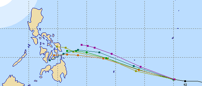
Only the US-Navy (violet) and the Koreans (olive) predict a northern track. All other agencies predict landfall either in northern Surigao or southern Leyte. Multi Agency forecast by Michael Padua.
Silent Gardens trusts in JMA’s forecasts
We receive our weather data from Tokyo and Chiba. Some data arrives every 30 minutes, other data comes in 1 hour and 3 hour intervals. This fast update allows us to analyze the dynamic of the weather. The US Navy (JTWC) also provides good fercast data, but they do it in a strict 6 hours rhythm. Please find below the newest JMA forecast from 5:00 p.m. (PST)
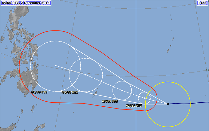
The yellow circle indicates the zone with wind speeds of at least 30 kts = 55 km/h. The red line delimits the storm warning zone. The white circles indicate the probability zone in which the storm can move. The line connecting the centers of these circles is the track forecast. The actual storm will not follow this line but stay within the white circles.
We now start to put all significant storm data as usual in a table. This table allows you to compare past and current development.
HAGUPIT/(Ruby)* Storm data:
| Name (INTL. / local): | HAGUPIT / (Ruby)* |
| Class: | Tropical Storm |
| Time/Date of observation: | 05:00 PM on December 02, 2014 |
| Location of Center: | 6.2º North 144.2º East |
| Moving Direction and Speed: | West @ 35 km/h |
| Moving towards: | Yap |
| Distance from the Philippines: | 2080 km SE of Surigao |
| Estimated Date / Time of Landfall: | n/a |
| Max. Wind Speed near Center: | 83 km/h |
| Peak Wind Gusts: | 120 km/h |
| Minimum Central Pressure: | 990 hPa |
| Diameter: | 330 km |
| 24h Rainfall near Center: | n/a |
| Max. Wave Height: | 7 – 9 m |
| Here you find how to read and understand this data | |
* The local name Ruby has not yet been assigned but is next on the list
Next update tomorrow morning after breakfast!
Nearly real-time storm information
[GARD]
Related posts
 December 2, 2014 Tropical Storm HAGUPIT is intensifying Tropical Storm HAGUPIT (upgradet from TD 22W) is intensifying. At 8:45 a.m. this morning the storm was running west at 35 km/h. This storm […]
- August 20, 2013 Severe Tropical Storm TRAMI / Maring intensifying Severe Tropical Storm TRAMI / Maring is still intensifying while moving around in strange patterns. The storm has now a central pressure […]
- November 26, 2014 Ferries sunk? Ferries sunk? All our communication channels are going mad. A first message informed us that a boat sunk between Benoni (Camiguin) and […]
- February 15, 2012 Floods in Mindanao – soon in the Southern Visayas The floods have begun. Near General Santos (Southern Mindanao) hundreds of houses in two major villages here were submerged in floodwaters […]
- May 1, 2013 Astonishing Camiguin Camiguin is known for its outstanding nature conservation, for its beaches and mountains and for its waterfalls and springs.
Among the […]


Recent Comments