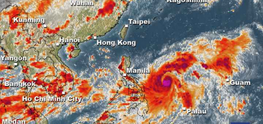
Typhoon BOPHA will hit Surigao and the Visayas Tuesday
Super Typhoon BOPHA is heading directly towards the Philippines. GDACS has issued a red alert for Palau and the Philippines.
Our office in Camiguin will probably be hit directly. We are now preparing for the worst case. We try to report as long as we can and as long as the network keeps up.
Special warning for coastal regions: The expected Storm Surge Height of 13 – 18 ft (4 – 5.5 m) together with a max. Wave Height of 48 ft (14.6 m) may create great devastation on the shores.
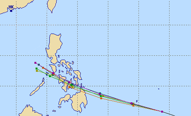
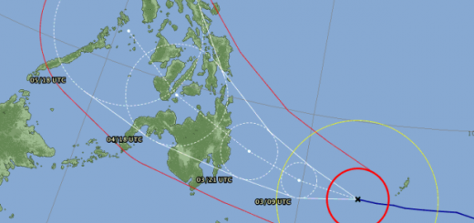
The multi-agency forecast has narrowed again and points now to Surigao and then the central Visayas.

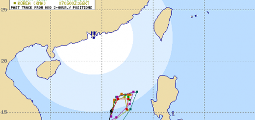
JMA now preview a track going from Surigao over the Bohol Sea hitting Butuan, Camiguin and Tagbilaran. Later crossing Cebu and Negros and moving towards Iloilo.
Storm data:
| Name (INTL. / local): | BOPHA |
| Class: | Typhoon Category 4 |
| Time/Date of observation: | 07:00 AM on December 02, 2012 |
| Location of Center: | 5.9º North 138.2º East |
| Moving Direction and Speed: | WNW @ 26 km/h = 16 mph |
| Moving towards: | Palau |
| Distance from the Philippines: | 1,330 km Mati City |
| Estimated Date / Time of Landfall: | ~ 05:00 PM on December 4, 2012 |
| Max. Wind Speed near Center: | 240 km/h = 149 mph |
| Peak Wind Gusts: | 295 km/h = 183 mph |
| Minimum Central Pressure: | 926 hPa |
| Diameter: | 720 km = 447 mi |
| 24h Rainfall near Center: | 310 mm = 12 in |
| Max. Wave Height: | 14.6 m = 48 ft |
Here you find how to read and understand this data  |
|
PAGASA warnings and signals:
| Signal 1 30-60 km/h |
Signal 2 60-100 km/h |
Signal 3 100-185 km/h |
Signal 4 above 185 km/h |
| n/a | n/a | n/a | n/a |
| Here you find you find more information about the storm warning signals |
|||
Related posts
 December 2, 2012 Super Typhoon BOPHA / Pablo – Update 09:00 PM on December 02, 2012 Super Typhoon BOPHA / Pablo has entered PAR (the Philippines Area of Responsibility). It continues its straight run towards northern […]
- December 8, 2012 Typhoon BOPHA/Pablo drives forecasters crazy – short update Typhoon BOPHA/Pablo is approaching northern Luzon. A final track cannot yet be seen. Track forecasts go from crossing Ilocos Norte to a […]
- December 8, 2012 Typhoon BOPHA/Pablo approaches Northern Luzon Typhoon BOPHA/Pablo is approaching northern Luzon. A final track cannot yet be seen. There are still too many parameters open for the […]
- December 8, 2012 Aquino declares the Philippines under state of national calamity President Benigno Aquino III on Saturday declared a state of national calamity due to the damage brought about by Typhoon […]
- December 8, 2012 Typhoon BOPHA/Pablo – the Movie We track the weather 7/24. if there is a dangerous situation, we inform our readers. One of our information sources is the Infrared (IR) […]


Recent Comments