Typhoon MAYSAK/Chedeng – weakening!
Typhoon MAYSAK/Chedeng is progressively weakening. At this moment it has still category 2 strength. The storm is getting disorganized in the dry air. There is hope that it will stall completely within 24 hours.
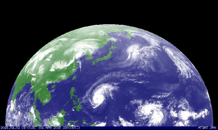
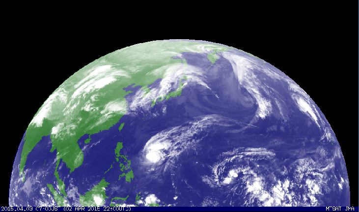
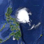
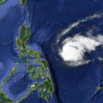
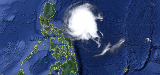
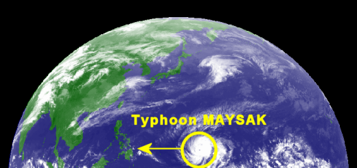
The satellite images from yesterday morning and today show the progressive disorganization of the cyclone. Here, the full 24 hours process can be observed.
Typhoon MAYSAK/Chedeng on 04/02/2015 at 08:00
Typhoon MAYSAK/Chedeng on 04/03/2015 at 08:00
There is now real chance that Typhoon MAYSAK/Chedeng will loose almost all energy. It then will cross northern Luzon on Easter Sunday as a tropical storm. Central pressure is increasing. It is now 945 hPa and is expected to reach 980 hPa in the night to Sunday.
Even as a Tropical Storm (TS), MAYSAK/Chedeng can still be nasty.Wind speed won’t be dangerous anymore, but heavy rainfall can cause floods and landslides. Please observe the official warnings.
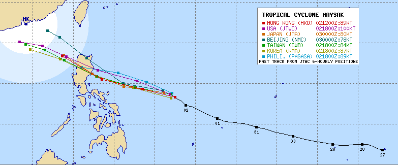
Track Forecast Typhoon MAYSAK/Chedeng
The erratic behavior of the cyclone makes forecasts difficult. The satellite images of the last 24 hours could make think that the storm is moving almost north. This is wrong! The satellite images are infra-red images and show the concentration of vapor. In the last 24 hours the storm accumulated more water in its northern parts – this creates the impression of a northern track.
Typhoon MAYSAK/Chedeng Storm data
| Name (INTL. / local): | MAYSAK /Chedeng |
| Class: | Typhoon Cat.2 |
| Time/Date of observation: | 06:00 a.m. on April 3, 2015 |
| Location of Center: | 13.9º North 131.7º East |
| Moving Direction and Speed: | Northwest @ 15 km/h |
| Moving towards: | Aurora |
| Distance from the Philippines: | 790 km E of Virac |
| Estimated Date / Time of Landfall: | Sunday morning |
| Max. Wind Speed near Center: | 157 km/h |
| Peak Wind Gusts: | 205 km/h |
| Minimum Central Pressure: | 945 hPa |
| Diameter: | 800 km |
| 24h Rainfall near Center: | 50 – 400 mm |
| Max. Wave Height: | n/a |
| Here you find how to read and understand this data | |
Next update this evening.
Almost real-time storm information
The animated pictures of this violent storm are fascinating
[GARD]
Related posts
 April 4, 2015 Typhoon MAYSAK/Chedeng – now Category 1 Typhoon MAYSAK/Chedeng again got weaker last night but got a bit better organized. This makes us think that the storm will reach the coast […]
- April 3, 2015 Typhoon MAYSAK/Chedeng – the last hours? Typhoon MAYSAK/Chedeng showed a really strange behavior today. It changed its cloud shape from the usual typhoon doughnut to a pear and […]
- April 2, 2015 Typhoon MAYSAK/Chedeng – appoaching Typhoon MAYSAK/Chedeng is still approaching. PAGASA and other government agencies start now to inform people. Don't mind this is the […]
- April 2, 2015 Typhoon MAYSAK/Chedeng now Cat.4 Typhoon MAYSAK/Chedeng continued to weaken while approaching the Philippines. Central pressure is now at 935 hPa. Forward speed slowed […]
- April 1, 2015 Typhoon MAYSAK/Chedeng – the Monster weakens Typhoon MAYSAK/Chedeng weakens. The monster storm lost a bit of its strength today but is still extremely strong. The central pressure […]


Recent Comments