Typhoon MAYSAK now Category 4
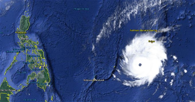
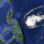
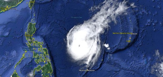
Typhoon MAYSAK is now Category 4 Cyclone. The storm is still heading straight west at 20 km/h. It got much stronger during the last 12 hours and has now a central pressure down to 930 hPa.
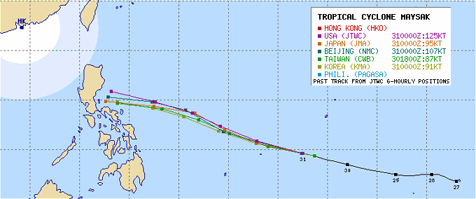
The powerful tropical cyclone MAYSAK has been rapidly gaining strength while moving over the warm waters of the Western Pacific Ocean. This storm poses a threat to the Philippines this weekend. Now at Near-Super Typhoon strength, MAYSAK continues to move between Guam and Palau. Forecast predict the storm to enter the Philippine Area of Responsibility (PAR) by early Thursday morning (April 02).
MAYSAK will reach Super Typhoon status within the next 12 to 24 hours, before it starts its weakening trend through 48 hours. From Wednesday to Friday the storm should continuously get weaker and reach the Philippines Saturday or Sunday as Category 1 Typhoon. The area of landfall will be somewhere between Bicol in the south and Aurora in the north.
Typhoon MAYSAK Storm data
| Name (INTL. / local): | MAYSAK / — |
| Class: | Typhoon Cat.4 |
| Time/Date of observation: | 08:45 a.m. on March 31, 2015 |
| Location of Center: | 9.6º North 142.5º East |
| Moving Direction and Speed: | West @ 22 km/h |
| Moving towards: | Philippines |
| Distance from the Philippines: | 1,875 km E of Surigao, Mindanao |
| Estimated Date / Time of Landfall: | Saturday or Sunday |
| Max. Wind Speed near Center: | 215 km/h |
| Peak Wind Gusts: | 260 km/h |
| Minimum Central Pressure: | 930 hPa |
| Diameter: | 655 km |
| 24h Rainfall near Center: | 100 – 300 mm |
| Max. Wave Height: | n/a |
| Here you find how to read and understand this data | |
Next update this evening
Almost real-time storm information
[GARD]
Related posts
 November 29, 2019 Red Alert – Typhoon KAMMURI / Tisoy moves towards Philippines People living in Catanduanes, Albay, and Camarines Provinces should now prepare the arrival of Typhoon KAMMURI / Tisoy. Beware also of […]
- October 18, 2016 Typhoon HAIMA/Lawin upgraded to category 4 becoming a Super Typhoon Typhoon HAIMA/Lawin has been upgraded to cyclone category 4. JMA has already attributed their highest category: VIOLENT
Typhoon […]
- October 17, 2015 Great Danger in Aurora – Typhoon KOPPU/Lando now Cat.4 Great Danger in Aurora - Typhoon KOPPU/Lando has now developed an eye and has been upgraded to Category 4. PAGASA has hoisted Storm SIgnal […]
- April 4, 2015 Typhoon MAYSAK/Chedeng – now Category 1 Typhoon MAYSAK/Chedeng again got weaker last night but got a bit better organized. This makes us think that the storm will reach the coast […]
- April 3, 2015 Typhoon MAYSAK/Chedeng – the last hours? Typhoon MAYSAK/Chedeng showed a really strange behavior today. It changed its cloud shape from the usual typhoon doughnut to a pear and […]


Recent Comments