HAGUPIT/Ruby – Samar again

Super Typhoon HAGUPIT/Ruby will hit Samar again – this is now sure. JMA forecasts rather the southeastern shores and JTWC predicts the center of the typhoon going through the northeastern parts.
After having hit Samar late Saturday night, the forecast tracks still split. JTWC sees the typhoon roaring up all Bicol towards Manila. JMA maintains the western direction and predicts the typhoon to follow the north coast of Panay from Roxas to Boracay.
Here in Camiguin it is the same uncomfortable feeling we had a year ago when HAIYAN/Yolanda first menaced the south and the destroyed Samar. We always get prepared and te we can do nothing than observe how the storm hits our northern neighbors. I detest this feeling of powerlessness.
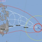
The Multi-Agency Tracks
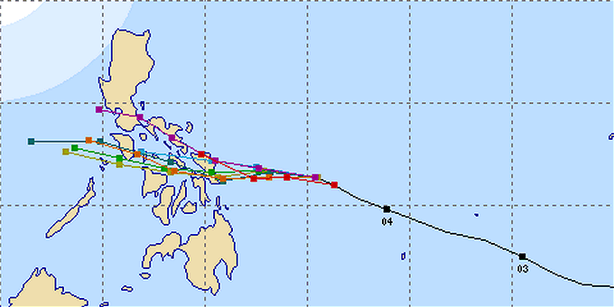
JTWC (US Navy) is the violet, most northern track. At the southern end are Korea (olive), Taiwan (green) and Japan (orange).
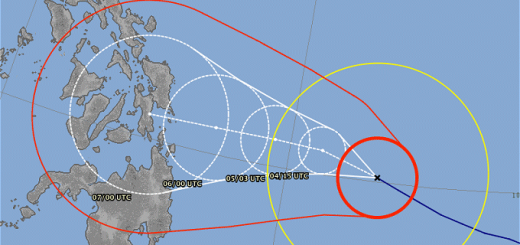
The JMA track forecast
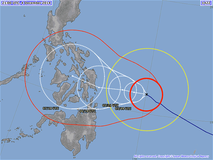
Update 09:00 a.m. JMA moves more north
The typhoon slows down its forward movement to 15 km/h. It also gets a bit weaker. The central pressure came up from 905 hPa to now 925 hPa. The storm is still extremely violent!
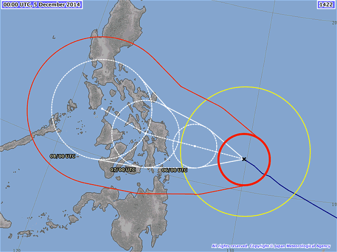
The next 6 to 12 hours will be determining of the exact location where the center of Super Typhoon HAGUPIT/Ruby will hit Samar. If you have read our earlier updates, you may remember that the track of the typhoon is remotely controlled by the High Pressure Area (HPA) over southern China. The series of HPAs is still flowing south, but the southernmost HPA has weakened from 1042 hPa to 1032 hPa. This leaves the typhoon a chance to move more north. The isobar map is here.
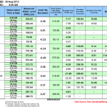
Super Typhoon HAGUPIT/Ruby Storm data
| Name (INTL. / local): | HAGUPIT/Ruby |
| Class: | Super Typhoon Cat.5 |
| Time/Date of observation: | 09:00 AM on December 5, 2014 |
| Location of Center: | 11.7º North 139.8º East |
| Moving Direction and Speed: | West – Northwest @ 15 km/h |
| Moving towards: | Samar |
| Distance from the Philippines: | 490 km East of Borongan |
| Estimated Date / Time of Landfall: | 20:00 – 24:00 Saturday evening |
| Max. Wind Speed near Center: | 250 km/h |
| Peak Wind Gusts: | 305 km/h |
| Minimum Central Pressure: | 925 hPa |
| Diameter: | 1000 km |
| 24h Rainfall near Center: | 150 – 500 mm |
| Max. Wave Height: | 10 – 15 m |
| Here you find how to read and understand this data | |
Next update maybe at noon, maybe in the evening.
Almost real-time storm information
[GARD]
Related posts
 December 6, 2014 Super Typhoon HAGUPIT/Ruby – final approach Super Typhoon HAGUPIT/Ruby - final approach. The typhoon maintained its strength with 925 hPa central pressure. It also maintained its […]
- December 4, 2014 HAGUPIT/Ruby – 900 hPa – EXTREME !!! Super Typhoon HAGUPIT/Ruby's central is going down to incredible 900 hPa !!! Only 5 hPa from HAIYAN/Yolanda. The forward speed is slowing […]
- December 4, 2014 Super Typhoon HAGUPIT/Ruby – I stay with JMA Super Typhoon HAGUPIT/Ruby - I stay with JMA. The battle between the typhoon track forecasters makes higher waves than the typhoon. After […]
- December 4, 2014 Typhoon HAGUPIT/Ruby – the tracks spread Typhoon HAGUPIT/Ruby – the tracks spread now more and more. The southernmost and fastest track is maintained by Japan's JMA. US's JTWC on […]
- August 26, 2013 Tropical Depression “91W / Nando” 560 km east of Baler, Aurora Tropical Depression “91W / Nando” moved northwards during the night without intensifying furthermore.
Bicol Region, Calabarzon and the […]


Recent Comments