Super Typhoon HAIMA/Lawin – Category 5 – Big Danger for Isabela and Cagayan
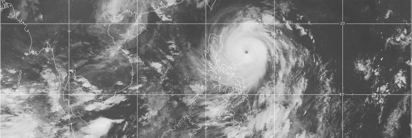
Super Typhoon HAIMA/Lawin continues to pose serious danger to the provinces of Isabela and Cagayan as it intensifies further and maintains its quick motion. Residents along its path are advised to take all necessary precautions NOW! This dangerous system is expected to continue moving fast within the next 24 hours at a speed of 26 km/hr towards Isabela-Cagayan Area.
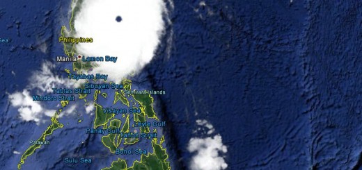
Super Typhoon HAIMA/Lawin: Landfall is expected tonight between 10:00 p.m. and 01:00 a.m. between Isabela and Cagayan.
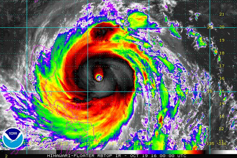
The Monster
Super Typhoon HAIMA/Lawin Track forecast:
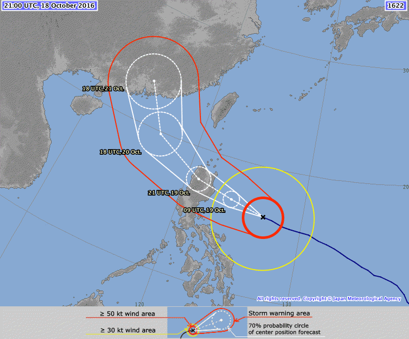
JMA and HKO still predict a more southern path than JTWC. We stay with the Japanese weather model which has often been the best track forecast.
Super Typhoon HAIMA/Lawin is comparable in track and strength of Super Typhoon ZEB/Iliang which crossed Northern Luzon on October 14, 1998.

Striking the Philippines at peak intensity, Zeb largely affected the island of Luzon, including the regions of Ilocos, Cagayan Valley, and Central Luzon. Wind gusts were estimated as high as 296 km/h (184 mph) in the country. The storm also dropped torrential rainfall, particularly in mountainous regions. In the municipality of Bakun, the 1,000-millimetre (39-inch) rain gauge overflowed, and in nearby La Trinidad, the rainfall was 1,116 mm (43.9 in) on October 14 alone. The latter total was estimated as a one-in-1,147-year event, based on the history of local rainfall totals.[21] In the city of Baguio, the precipitation reached 994.6 mm (39.16 in), enough to flood the town 9 m (30 ft) deep. The Binga and Ambuclao dams in Benguet were unable to support the rains from the storm, forcing them to be opened and flood three towns in neighboring Pangasinan. Minor street flooding occurred along the west coast near Manila.
Across Luzon, the high rains caused flooding, landslides, and halted construction of a dam in Bakun. Considered one of the strongest typhoons to hit the area in decades, Zeb knocked down tress and power lines, which covered roads and left areas isolated. The winds were strong enough to blow over a jeepney. Along its path, the storm destroyed 26,305 houses and damaged another 59,539,[20] mostly affecting those of weaker building materials. River flooding caused heavy damage to crops, estimated at ₱1.76 billion (1998 Philippine pesos, $41.3 million U.S. dollars); the storm destroyed 181,630 t (400,430,000 lb) of rice in Ilocos Region and Cagayan Valley. Most of the damage occurred in Luzon, with little impact elsewhere. The storm also marred the local infrastructure; areas in northeastern Luzon were isolated when landslides blocked a highway, and several other roads and bridges were impassible. Overall, Zeb killed 83 people in the country, while injuring another 63; most of the deaths were related to the landslides, and 33 of the deaths were in Cordillera Administrative Region. Overall damage was estimated at ₱5.375 billion (PHP, $126 million USD), which as of 2011 was the thirteenth-costliest typhoon in the Philippines and the fifth-costliest at the time.
Super Typhoon HAIMA/Lawin Storm data:
| Name (INTL. / local): | HAIMA / Lawin |
| Class: | Super Typhoon Cat.5 |
| Time/Date of observation: | 05:00 AM on October 19, 2016 |
| Location of Center: | 16.1º North 126.7º East |
| Moving Direction and Speed: | West-Northwest @ 31 km/h |
| Moving towards: | Isabela / Cagayan |
| Distance from the Philippines: | 496 km E of Casiguran, Aurora |
| Estimated Date / Time of Landfall: | tonight between 10:00 PM and 01:00 AM |
| Max. Wind Speed near Center: | 250 km/h |
| Peak Wind Gusts: | 300 km/h |
| Minimum Central Pressure: | 905 hPa |
| Diameter: | 855 km |
| 24h Rainfall near Center: | 25 – 350 mm |
| Max. Wave Height: | 10 – 12 m |
| Here you find how to read and understand this data | |
Nearly real-time storm information
[GARD]
Related posts
 May 10, 2015 Super Typhoon NOUL/Dodong Cat.5 now Super Typhoon Typhoon NOUL/Dodong has gained extreme strength. Central pressure fell down to 918 hPa and wind speed near the center is up […]
- April 1, 2015 Super Typhoon MAYSAK – not an April Fool Super Typhoon MAYSAK again got stronger last night. The central pressure of the cyclone had been down to 905 hPa. This makes MAYSAK one of […]
- May 13, 2011 Still no information – wrong information – incomplete information at NAIA It is true that in Manila's NAIA airport with its 4 terminals it is difficult to find any valid information.
One of our readers sent us […]
- February 27, 2019 Philippine Airlines – The PAL Facebook Scam
The PAL Facebook Scam
Today many of my Facebook friends and even Real-Life friends got attracted by this scam:
Everything is […]
- January 18, 2017 Wings Lounge NAIA 3 – we tested twice and slept well Wings Lounge NAIA 3 is the nearest possible place to relax or have a nap when in Manila International Airport.
We had often read about […]


Recent Comments