Super Typhoon HAIYAN / Yolanda – a big menace
First of all sorry for the month off. I had been traveling between snow, ice and rocks and Röschti.
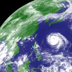
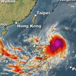
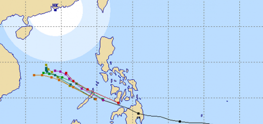
Super Typhoon HAIYAN / Yolanda, currently a Cat. 4 Typhoon, is approaching the Philippines.
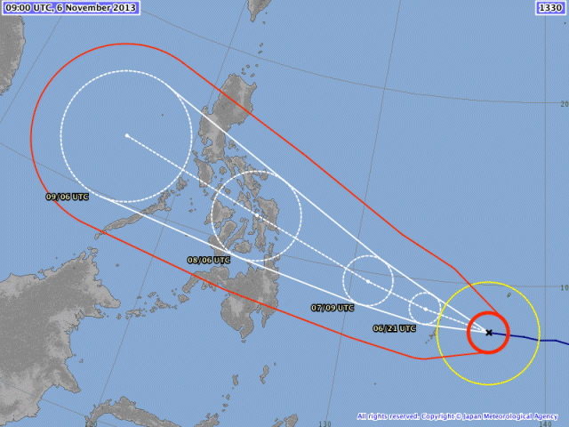
The probability cone is still large and goes from Camiguin in the south to Pampanga in the north. If the storm is a straight-runner it will hit the south. If it follows a “Coriolis” track, it will hit rather the center to north.
The JMA forecast previews a “Coriolis” track, meaning that the typhoon will turn from west to north-west.
At 5:00 p.m. today the storm had been at 210 km east of the Philippines Area of Responsibility (PAR). With its forward speed of 41 km/h in direction West to WNW, the storm will enter PAR around 2:00 a.m. tomorrow morning. This forward speed is very high. Usual typhoons move at around 20 km/h.

All forecast models converge in a nearly single track. Landfall will be in southern Samar and then the typhoon will run towards northern Panay and Boracay. It might directly affect southern Mindoro.
Storm data:
| Name (INTL. / local): | HAIYAN / Yolanda |
| Class: | Super Typhoon Category 4 |
| Time/Date of observation: | 05:00 PM on November 06, 2013 |
| Location of Center: | 7.7º North 136.9º East |
| Moving Direction and Speed: | West – WNW @ 41 km/h (extreme!) |
| Moving towards: | Southern Samar |
| Distance from the Philippines: | 1210 km ESE of Siargao Island |
| Estimated Date / Time of Landfall: | ~ 11:00 AM on November 8, 2013 |
| Max. Wind Speed near Center: | 250 km/h |
| Peak Wind Gusts: | 305 km/h |
| Minimum Central Pressure: | 922 hPa |
| Diameter: | 720 km |
| 24h Rainfall near Center: | 455 mm |
| Max. Wave Height: | 12 m = 40 ft |
Here you find how to read and understand this data  |
|
Animated weather movies are here
Please find below some hints:
Do now:
- Store an adequate supply of food and clean water. Prepare food that need not be cooked.
- Keep flashlights, candles and battery-powered radios within easy reach.
- Examine your house and repair its unstable parts.
- Always keep yourself updated with the latest weather report.
- Secure domesticated animals in a safe place.
- For fisher folks, place boats in a safe area.
During the typhoon:
- Stay inside the house.
- Always keep yourself updated with the latest weather report.
- If safe drinking water is not available, boil water for at least 20 minutes. Place it in a container with cover.
- Keep an eye on lighted candles or gas lamps.
- Do not wade through floodwaters to avoid being electrocuted and contracting diseases.
If there is a need to move to an evacuation center, follow these reminders:
- Evacuate calmly.
- Close the windows and turn off the main power switch.
- Put important appliances and belongings in a high ground.
- Avoid the way leading to the river.
- Bring clothes, first aid kit, candles/flashlight, battery-powered radio, food, etc.
After the typhoon:
- If your house is destroyed, make sure that it is stable when you enter.
- Beware of dangerous animals such as snakes that may have entered your house.
- Watch out for live wires or outlet immersed in water.
- Report damaged electrical cables and fallen electric posts to the authorities.
- Do not let water accumulate in tires, cans or pots to avoid creating a favorable condition for mosquito breeding.
Related posts
 July 10, 2013 Typhoon SOULIK/Huaning has entered PAR The Powerful Typhoon SOULIK / 07W has entered the northeastern border of the Philippine Area of Responsibility (PAR) and got the local […]
- October 18, 2016 Typhoon HAIMA/Lawin upgraded to category 4 becoming a Super Typhoon Typhoon HAIMA/Lawin has been upgraded to cyclone category 4. JMA has already attributed their highest category: VIOLENT
Typhoon […]
- November 18, 2015 Tropical Storm IN-FA moving west Tropical Storm IN-FA is moving west. This storm is still far away from the Philippines but has the potential to amplify to a Typhoon Cat. […]
- October 17, 2015 Great Danger in Aurora – Typhoon KOPPU/Lando now Cat.4 Great Danger in Aurora - Typhoon KOPPU/Lando has now developed an eye and has been upgraded to Category 4. PAGASA has hoisted Storm SIgnal […]
- October 15, 2015 Tropical Storm KOPPU/Lando a bit slower Tropical Storm KOPPU/Lando advanced a bit slower than forecasts predicted. While still moving westward it gained a bit of strength. The […]


Thank you René. we know we cannot help or avoid the typhoon but our thoughts and hopes are with you and our beloved family