Great Danger in Aurora – Typhoon KOPPU/Lando now Cat.4
Great Danger in Aurora – Typhoon KOPPU/Lando has now developed an eye and has been upgraded to Category 4. PAGASA has hoisted Storm SIgnal #4 over Aurora. The cyclones forward speed is very low, 10 to 15 km/h.
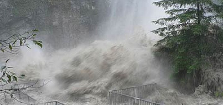
The situation in Aurora province is getting extremely dangerous. Wind speeds of 210 to 250 km/h are to be expected tonight. Such winds will destroy lightly built houses and knock down many trees. On the coast a big storm surge is expected to be as high as 14 meters (46 feet). This is the height of a 4 storeys building.
At 7:33 p.m. a plane from the United Nations /ETH628) coming from Bangkok has landed in Manila. We do not yet know what their mission will be. Already first relief goods?
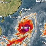
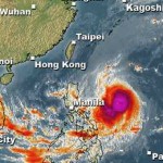
Typhoon KOPPU/Lando track forecast
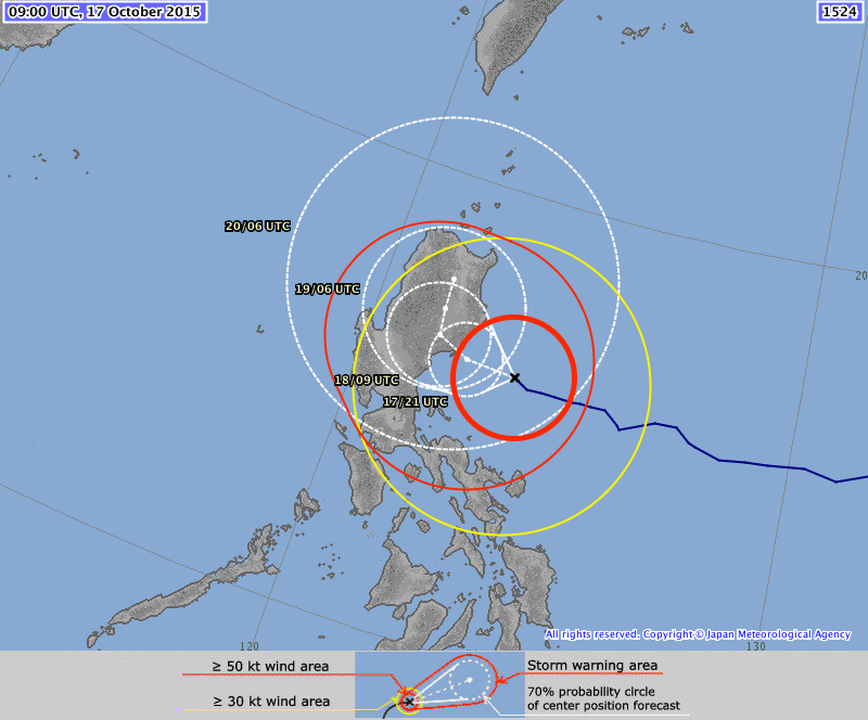
During the last 3 hours the cyclone has slightly changed its track to northwest.
The Big Danger
Typhoon KOPPU/Lando started to interact with his follower, Typhoon CHAMPI. Although CHAMPI will not hit the Philippines as is already turning slightly northwest, it influences the forward speed of KOPPU/Lando. High Pressure Areas (HPA) over Korea and Japan also slow down the northward movement. The result is that Typhoon KOPPU/Lando might hover over northern Luzon until Wednesday next week.
With its diameter of about 850 km, Typhoon KOPPU/Lando will continue to bring in big masses of water and spill it over northern Luzon. Even if wind speeds will decrease when the storm is over land, the heavy rains will trigger floods and landslides.
Philippine President Benigno Aquino III warned that Typhoon KOPPU/Lando could be uniquely destructive because it would bring intense rain over a long period of time. Well, that’s politics.
PAGASA Storm Signals
Storm Signal #4: winds of 171 to 220 kph within 12 hours
Aurora
Storm Signal #3: winds of 121 to 170 kph within 18 hours
Isabela, Quirino, Nueva Vizcaya, Nueva Ecija, Ifugao, Northern Quezon including Polillo Islands
Storm Signal #2: winds of 61 to 120 kph within 24 hours
Cagayan including Calayan and Babuyan group of Islands, Benguet, Mt. Province, Abra, Kalinga, Apayao, Pangasinan, La Union, Ilocos Sur, Ilocos Norte, Bulacan, Pampanga, Tarlac, Rizal, rest of Quezon, Camarines Norte, Metro Manila
Storm Signal #1: winds of 30 to 60 kph within 36 hours
Batanes, Zambales, Bataan, Cavite, Laguna, Batangas, Albay, Camarines Sur, Catanduanes
KOPPU/Lando Storm data:
| Name (INTL. / local): | KOPPU/Lando |
| Class: | Typhoon Category 4 |
| Time/Date of observation: | 05:00 PM on October 17, 2015 |
| Location of Center: | 16.0° North 123.5° East |
| Moving Direction and Speed: | West @ 10-15 km/h |
| Moving towards: | Northern Luzon |
| Distance from the Philippines: | 210 km E of Baler (Aurora) |
| Estimated Date / Time of Landfall: | Sunday morning, Aurora |
| Max. Wind Speed near Center: | 160 km/h |
| Peak Wind Gusts: | 250 km/h |
| Minimum Central Pressure: | 930 hPa |
| Diameter: | 850 km |
| 24h Rainfall near Center: | 100 – 500 mm |
| Max. Wave Height: | Extreme storm surge!!! |
| Here you find how to read and understand this data | |
Nearly real-time storm information
Next update tomorrow morning.
[GARD]
Related posts
 October 18, 2015 Landfall over Casiguran – Aurora Super Typhoon KOPPU/Lando has made Landfall between Baler and Casiguran in Aurora province around 01:00 a.m. this morning. Cyclonic winds […]
- October 18, 2016 Typhoon HAIMA/Lawin upgraded to category 4 becoming a Super Typhoon Typhoon HAIMA/Lawin has been upgraded to cyclone category 4. JMA has already attributed their highest category: VIOLENT
Typhoon […]
- October 18, 2015 Too slow! Typhoon KOPPU/Lando creeps over land Too slow! Typhoon KOPPU/Lando moves only very slowly northwest. Forward speeds are between 3 and 9 km/h! The Typhoon continues to bring […]
- October 17, 2015 Typhoon KOPPU/Lando now Category 3 Typhoon KOPPU/Lando gained strength and is now a Typhoon Category 3. The cyclone has slowly approached the Philippines and is now 285 km […]
- October 16, 2015 Typhoon KOPPU/Lando is now affecting the Philippines Typhoon KOPPU/Lando is already near and upgraded to Cat.2. PAGASA sees it 510 km off the coast of Aurora. The strong winds and heavy […]


Recent Comments