Typhoon HAGUPIT/Ruby – slow – slow – slow

Typhoon HAGUPIT/Ruby is moving very slowly over the Visayas. With an average forward speed of 10 km/h the typhoon will need about 56 hours to cross the Philippines.
After having made landfall at 9:15 p.m. yesterday evening over Dolores in Eastern Samar. The storm is now moving towards the island of Masbate. The radius of damaging winds with 95 km/h and more is now 120 km. This means that strong storm winds last for up to 24 hours in the touched regions. Usual ar 4 to 8 hours.
Fortunately Typhoon HAGUPIT/Ruby got a bit weaker. Central pressure is now 945 hPa. Winds blow with 185 km/h near he center and gusts go up to 220 km/h.
The government said more than 600,000 people in coastal areas were in evacuation centers, and many others were expected to pour in as the slow-moving “Ruby” was expected to make four more landfalls today – between 8 a.m. and 10 a.m. in Masbate; between 2 p.m. and 4 p.m. on Sibuyan Island; between 5 p.m. and 7 p.m. in Romblon; and between 8 p.m. on Tablas Island.
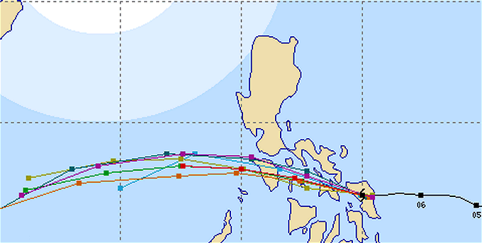
Multi-Agency track forecast
There is no more discussion where the storm will pass.
The JMA track forecast
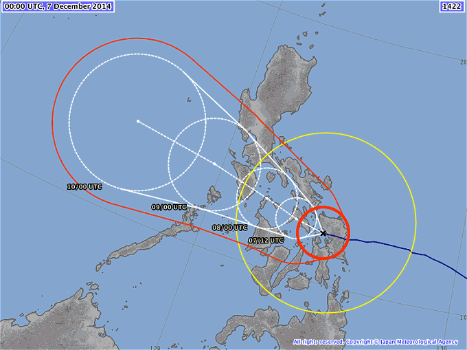
The red circle indicates the zone of strong storm winds of over 90 km/h. This wind speed is damaging. Inside the yellow circle wind speed is more than 50 km/h.
Camiguin Weather (Agoho Beach)

Our weather station is optimistic 😉

During last night the wind got stronger and blows in gusts. The waves are now more than 2 meters high. Still no rain.
Typhoon HAGUPIT/Ruby Storm data
| Name (INTL. / local): | HAGUPIT/Ruby |
| Class: | Typhoon Cat.3 |
| Time/Date of observation: | 09:00 AM on December 7, 2014 |
| Location of Center: | 11.9º North 124.6º East |
| Moving Direction and Speed: | West @ 10 km/h |
| Moving towards: | Masbate |
| Distance from the Philippines: | inside |
| Estimated Date / Time of Landfall: | multiple islands |
| Max. Wind Speed near Center: | 175 km/h |
| Peak Wind Gusts: | 250 km/h |
| Minimum Central Pressure: | 945 hPa |
| Diameter: | 850 km |
| 24h Rainfall near Center: | 100 – 400 mm |
| Max. Wave Height: | 8 – 12 m |
| Here you find how to read and understand this data | |
Next update this afternoon / evening.
Almost real-time storm information
[GARD]
Related posts
 December 6, 2014 Typhoon HAGUPIT/Ruby 6 p.m. update Typhoon HAGUPIT/Ruby is continuously approaching Samar. JMA classifies the typhoon as "very strong" this means still Cat.4. The expected […]
- December 5, 2014 HAGUPIT/Ruby – short update 9 p.m. Typhoon HAGUPIT/Ruby again intensifying and moving towards Samar - JMA has again updated their forecast - Data from 8:40 p.m.(PST) - […]
- December 5, 2014 HAGUPIT/Ruby – slowed down and weakened Typhoon HAGUPIT/Ruby has slowed down its forward speed from 30 km/h to only 15 km/h. The typhoon also weakened a bit and is now a Typhoon […]
- January 24, 2013 Tscherina Nora Janisch found – in prison We refer to our message "Tscherina Nora Janisch is missing" from January 16, 2013.
PHUKET: A 22-year-old Swiss student tourist reported […]
- April 9, 2008 Again Cebu Pacific Air Again Cebu-Pacific Air - The real Pinoy Airline - The story about Philip
Today I had to travel from Kalibo (KLO) to Cagayan de Oro (CGY). […]


Recent Comments