Super Typhoon USAGI / Odette hitting Batanes tonight

Typhoon USAGI / Odette as an extremely dangerous Category 5 Super Typhoon endangers extreme Northern Luzon and Southern Taiwan particularly the Batanes Islands. Outer rainbands now spreading across all Northern Luzon.
PAGASA has now declared Storm Signal #4 over the Batanes Islands. Storm Signal #4 means:
- Coconut plantation may suffer extensive damage
- Many large trees maybe uprooted
- Rice and corn plantation may suffer severe losses
- Most residential and institutional buildings of mixed construction material maybe severely damaged
- Electrical power distribution and communication services maybe severely disrupted
- In the overall, damage to affected communities can be very heavy
- The situation is potentially very destructive to communities
- All travel and outdoor activities should be cancelled
- Evacuation to much safer shelters should have been completed earlier since it maybe too late under this situation
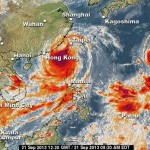
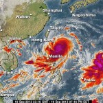
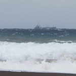
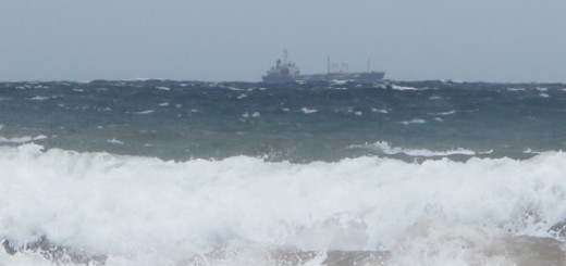
The picture of the typhoon is terrifying
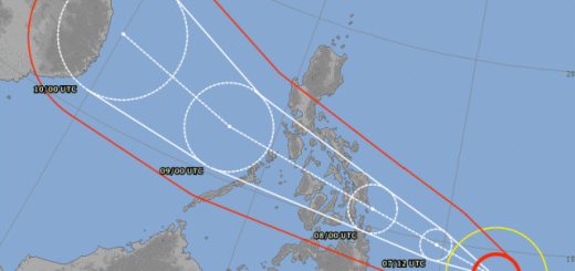
.The forecast track shows that the typhoon will reach the Batanes Islands tomorrow morning.

PAGASA has declared Storm Signal #4 in:
- Batanes Group of Islands
PAGASA Storm Signal #3 in:
- Calayan Islands
- Babuyan Group of Islands.
PAGASA Storm Signal #2 in:
- Cagayan
- Apayao
- Ilocos Norte
PAGASA Storm Signal #1 in:
- Abra
- Kalinga
- Isabela
- Northern Aurora
- Quirino
- Nueva Vizcaya
- Benguet
- La Union
- Ilocos Sur
- Mountain Province
- Ifugao
Luzon Dam Status:
3 dams have spill gates open: Ambuklao, Binga, Magat.
All dams have more than 1 meter overflow margin.
3 dams have spill gates open: Ambuklao, Binga, Magat.
All dams have more than 1 meter overflow margin.
Storm data:
| Name (INTL. / local): | USAGI / Odette |
| Class: | Super Typhoon Category 5 |
| Time/Date of observation: | 05:00 p.m. on September 20, 2013 |
| Location of Center: | 19.8º North 124.1º East |
| Moving Direction and Speed: | WNW at 15 km/h |
| Moving towards: | Batanes Islands / Taiwan |
| Distance from the Philippines: | 220 km East of Basco, Batanes |
| Estimated Date / Time of Landfall: | Batanes Islands Saturday 08:00 a.m. |
| Max. Wind Speed near Center: | 245 km/h |
| Peak Wind Gusts: | 295 km/h |
| Minimum Central Pressure: | 910 hPa |
| Diameter: | 1010 km (very large) |
| 24h Rainfall near Center: | 500 mm |
| Max. Wave Height: | 14 m |
Here you find how to read and understand this data  |
|
We keep an eye on this storm. For more and real-time information see here:
Old Weather Page
New Weather Page
Related posts
 September 21, 2013 Typhoon USAGI / Odette moving towards Hongkong Typhoon USAGI / Odette is still inside PAR (Philippines Area of Responsibility) but is now moving at 19 km/h towards Hongkong. The typhoon […]
- September 21, 2013 Super Typhoon USAGI / Odette made landfall in Itbayat Super Typhoon USAGI / Odette had a bit weakened down to category 4 before making landfall in Itbayat, Batanes Islands.
At 7:00 a.m. the […]
- September 20, 2013 Super Typhoon USAGI / Odette is now Category 5 At 4:00 a.m. today, the eye of Super Typhoon USAGI / Odette was located at 410 km East of Aparri, Cagayan (18.9°N, 126.0°E). Maximum […]
- October 8, 2014 Violent Typhoon VONGFONG / Ompong Violent Typhoon VONGFONG / Ompong has reachd Category 5 and is a Super Typhoon now. It's central pressure is incredibly low at 900 hPa. […]
- September 20, 2013 Extremely strong Habagat Super Typhoon USAGI / Odette enhances the sout-west monsoon (Habagt). Strong winds with gusts up to 80 km/h and occasionally strong […]


Recent Comments