Tropical Storm BANYAN / Ramon – update 12:00 PM 10/12/2011
Tropical Storm BANYAN / Ramon has rapidly accelerated & was relocated farther to the West.It is now in the vicinity of Cebu Island. Wide swath of intense rainbands affect the Southern Philippines.
Most of the islands of the Visayas and parts of northern Mindanao are under PAGASA Storm Signal 1.
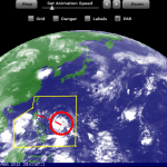
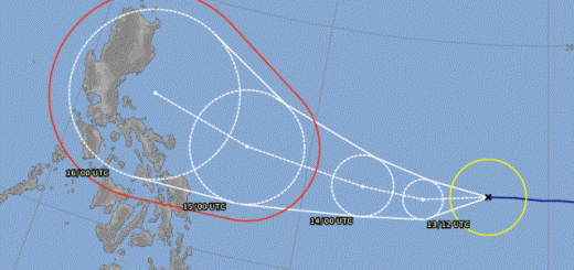
The US Navy forecast

The PAGASA forecast

PAGASA STROM SIGNALS
Signal No.1 (45-60 km/h winds):
– Marinduque
– Mindoro Provinces
– Romblon
– Camarines Sur
– Southern Quezon
– Catanduanes
– Albay
– Burias Island
– Sorsogon
– Ticao Island
– Masbate
– Coron Island
– Samar Provinces
– Leyte Provinces
– Cebu
– Bohol
– Panay Island
– Guimaras
– Negros Provinces
– Siquijor Island
– Agusan del Norte
– Surigao del Sur
– Surigao del Norte
– Dinagat
– Island
– Siargao Island
CURRENT STORM INFORMATION BANYAN / Ramon
| Time/Date: | 12:00 PM October 12 2011 |
| Location of Center: | 10.2º N Latitude, 123.5º E Longitude |
| Distance: | 45 km WSW of Metro Cebu |
| MaxWinds: | 65 km/h (35 kts) near the center |
| Peak Wind Gusts: | 85 km/h (45 kts) |
| Present Movement: | West-North-West at 31 km/h (17 kts) |
| Towards: | Negros-Southern Panay Area |
| Expected Landfall: | N/A |
| 24hr Rainfall: | 510 mm |
| Minimum Central Pressure: | 996 millibars (hPa) |
| Size: | 665 km (360 nm) |
| Max Wave Height: | 4m (13 ft) |
Near real time weather information is here 
Next storm update around 12:00 AM (00:00) UTC+8
Related posts
 November 18, 2015 Tropical Storm IN-FA moving west Tropical Storm IN-FA is moving west. This storm is still far away from the Philippines but has the potential to amplify to a Typhoon Cat. […]
- July 8, 2015 CHAN-HOM and NANGKA – Habagat Amplifiers Last weekend, Tropical Storm LINFA/Egay brought a lot of rain over northern Luzon. Now it is enhancing the southwest monsoon (Habagat) […]
- August 10, 2013 Tropical Storm UTOR / Labuyo getting stronger During last night Tropical Depression 11W / Labuyo has strengthened and is now a Tropical Storm called UTOR / Labuyo. It continues to move […]
- July 8, 2013 Tropical Storm SOULIK/07W is getting stronger and bigger The strong Tropical Depression (TD) north of Guam has strengthened into a Tropical Storm SOULIK/07W. It is now passing very close to the […]
- September 22, 2012 Tropical Storm “JELAWAT / Lawin” approching the Philippines Tropical Storm “JELAWAT / Lawin” has intensified. The outer rainbands already touch the eastern Philippine islands.
“JELAWAT / Lawin” is […]


Recent Comments