Tropical Storm RAMMASUN approaches
Tropical Storm RAMMASUN continues on its straight western track. The storm has maintained its strength and tonight will enter PAR (the Philippine’s Area of Responsibility).
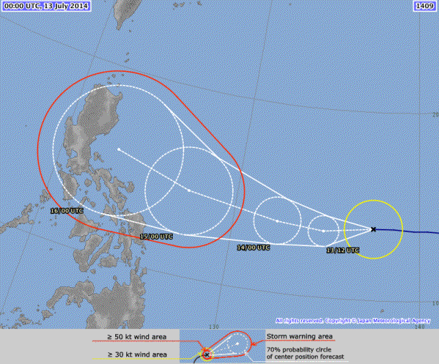
Forecasts predict that the track will slightly bend from straight west to west-northwest in the coming 24 to 36 hours. If the storm follows this new track, it will make landfall in Aurora between Baler and Casiguran on Wednesday evening.
As usual, we rely on the forecast of JMA, the Japan Meteprological Agency. You may also want to see their barometric map which not only shows the storm’s pressure but also other low and high pressure areas in the region. These other systems may influence the direction and the development of Tropical Storm RAMMASUN. There is a weak high pressure north of RAMMASUN that prevents the storm from turning north-west.
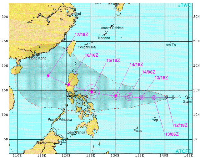
Below is the map of JTWC (US NAVY). It shows that Tropical Storm RAMMASUN will become a typhoon Cat.1 when it enters PAR. Maximum strength will be Cat.2 just off the coast of Aurora.
Rammasun Storm data:
| Name (INTL. / local): | RAMMASUN |
| Class: | Tropical Storm |
| Time/Date of observation: | 06:30 AM on July 13, 2014 |
| Location of Center: | 13.6º North 139.9º East |
| Moving Direction and Speed: | West @ 24 km/h |
| Moving towards: | Aurora (Luzon) |
| Distance from the Philippines: | 1935 km ESE of Casiguran, Aurora |
| Estimated Date / Time of Landfall: | Wednesday evening, July 16 |
| Max. Wind Speed near Center: | 65 km/h |
| Peak Wind Gusts: | 85 km/h |
| Minimum Central Pressure: | 996 hPa |
| Diameter: | 335 km (rather small) |
| 24h Rainfall near Center: | 200 – 350 mm |
| Max. Wave Height: | n/a |
| Here you find how to read and understand this data | |
Nearly real-time storm information
[GARD]
Related posts
 July 14, 2014 Tropical Storm RAMMASUN / Glenda Tropical Storm RAMMASUN has entered PAR and got the Filipino name "Glenda". Tropical Storm RAMMASUN/Glenda is a "straight runner" and has […]
- November 18, 2015 Tropical Storm IN-FA moving west Tropical Storm IN-FA is moving west. This storm is still far away from the Philippines but has the potential to amplify to a Typhoon Cat. […]
- October 16, 2015 Typhoon KOPPU/Lando brings first heavy rains Typhoon KOPPU/Lando brings the first heavy rains to the Philippines. Winds on the north-east coast are now stronger than 30 knots (55 […]
- July 8, 2015 CHAN-HOM and NANGKA – Habagat Amplifiers Last weekend, Tropical Storm LINFA/Egay brought a lot of rain over northern Luzon. Now it is enhancing the southwest monsoon (Habagat) […]
- May 10, 2015 Tropical Storm DOLPHIN – The next bad guy? You may remember our storm report from May 8. We then reported a strange guy developing around Palikir, Micronesia. This strange guy now […]


Recent Comments