Typhoon MATMO/Henry has turned north
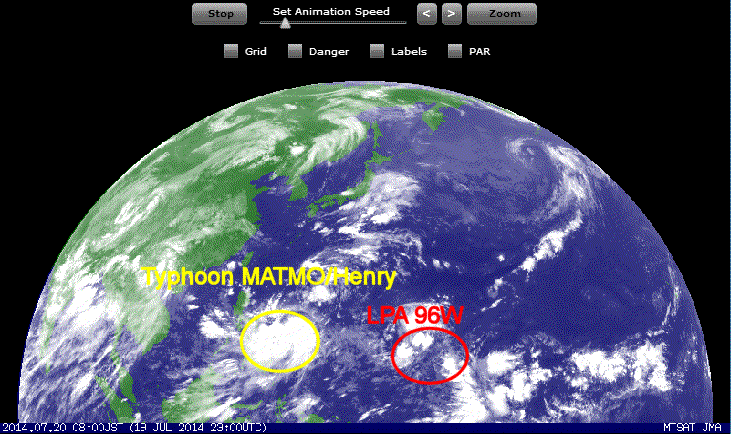
Typhoon MATMO/Henry has turned north last night. Unfortunately we could not report these good news because we had a long lasting brownout.
The storm is now 645 km east-southeast of Virac, Catanduanes. It moves very slowly northwest at 5 km/h. The typhoon will now accelerate to a forward speed of about 20 km/h and turn even more northward.
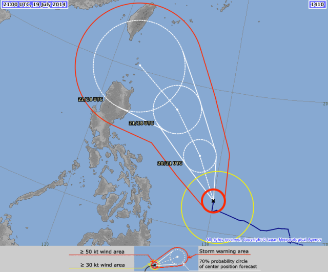
Above track from JMA is astonishing because it shows a change of direction of more than 90°. There had been no LTO traffic enforcer there to tell the typhoon to deviate to the right. It is rather a glitch of the algorithm in relation to the projection of the map. JMA uses a conic projection while the US Navy uses a Mercator projection.

MATMA/Henry Storm data:
| Name (INTL. / local): | MATMA /Henry |
| Class: | Typhoon Cat.1 |
| Time/Date of observation: | 05:00 AM on July 19, 2014 |
| Location of Center: | 12.1º North 130.2º East |
| Moving Direction and Speed: | North-Northwest @ 20 km/h |
| Moving towards: | Batanes Islands |
| Distance from the Philippines: | 645 km ESE of Virac |
| Estimated Date / Time of Landfall: | n/a |
| Max. Wind Speed near Center: | 120 km/h |
| Peak Wind Gusts: | 150 km/h |
| Minimum Central Pressure: | 974 hPa |
| Diameter: | 550 km |
| 24h Rainfall near Center: | 200 – 400 mm |
| Max. Wave Height: | 10 – 12 m |
| Here you find how to read and understand this data | |
Nearly real-time storm information
And there is already a new LPA developing south-east of Guam.
[GARD]
Related posts
 July 3, 2016 2016 Storm Season approaching – first Tropical Storm Nepartak 2016 Storm Season is beginning. It is not yet the Typhoon Season 2016, but first tropical storm is building up in the east. Tropical Storm […]
- May 19, 2016 1000th Earthquake 2016 in the Philippines The 1000th Earthquake occurred last night at 09:05 PM near Calintaan, Occidental Mindoro. The first 4 months of 2016 we recorded more […]
- April 24, 2016 Philippines – Fee-lippines – tourists and locals complain Philippines - Fee-lippines is one of the reasons why tourism stalls in this country. There are many more, but all these separate taxes and […]
- November 19, 2015 Cyclone IN-FA | short update Cyclone IN-FA has gained strength and is now a Typhoon Category 1. Fortunately the track of this storm has already started to veer to […]
- October 25, 2015 Indonesian Smoke over Southern Philippines Last Friday a friend living uphill in Camiguin texted me to ask what was happening. She couldn't see White Island laying only 2.75 km from […]


Recent Comments