Tropical Storm MATMO/Henry

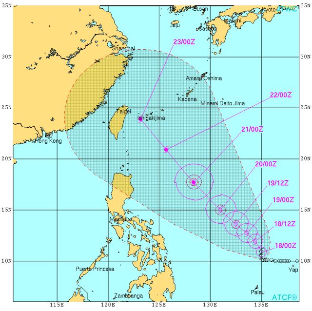
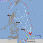
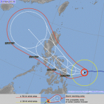
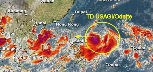
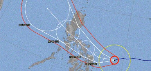
Tropical Storm MATMO/Henry has intensified as it entered PAR. Tropical Storm MATMO/Henry is expected to continue moving slowly north-northwestward during the next 24 to 48 hours. On the forecast track, the storm will continue to move across the central and northern portion of the Philippine Sea through Monday morning. The storm will not make landfall in the Philippines.
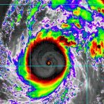
Meanwhile Typhoon RAMMASUN/Glenda has intensified and is now a Typhoon Cat.4. Typhoon RAMMASUN/Glenda will make landfall today in the vicinity of Hainan (China).
Begin of next week, Tropical Storm MATMO/Henry might be upgraded to a Typhoon Cat.1 before approaching Taiwan.
CAUTION: Although Tropical Storm MATMO/Henry will not touch the Philippine islands, it probably will enhance Habagat, the south-west monsoon. At this moment it is still Typhoon RAMMASUN/Glenda that strong Habagat in Palawan and Luzon’s west-coast.
MATMA/Henry Storm data:
| Name (INTL. / local): | MATMA /Henry |
| Class: | Tropical Storm |
| Time/Date of observation: | 06:00 AM on July 18, 2014 |
| Location of Center: | 10.4º North 134.9º East |
| Moving Direction and Speed: | North-Northwest @ 7 km/h |
| Moving towards: | Taiwan |
| Distance from the Philippines: | 985 km ENE of Surigao |
| Estimated Date / Time of Landfall: | n/a |
| Max. Wind Speed near Center: | 65 km/h |
| Peak Wind Gusts: | 85 km/h |
| Minimum Central Pressure: | 996 hPa |
| Diameter: | 445 km |
| 24h Rainfall near Center: | 100 – 400 mm |
| Max. Wave Height: | n/a |
| Here you find how to read and understand this data | |
Nearly real-time storm information
[GARD]
Related posts
 July 19, 2014 MATMO Henry could become dangerous Tropical Storm MATMO/Henry continued on a nearly westward track and approached the Philippine islands during the last 24 hours. This […]
- July 14, 2014 Tropical Storm RAMMASUN / Glenda Tropical Storm RAMMASUN has entered PAR and got the Filipino name "Glenda". Tropical Storm RAMMASUN/Glenda is a "straight runner" and has […]
- September 2, 2013 Landslide – what landslide? It’s sunny in the Philippines People ask me often about our landslide warnings. Most tourists cannot imagine what it means. Landslide? What is sliding?
Our northern […]
- October 18, 2016 Typhoon HAIMA/Lawin upgraded to category 4 becoming a Super Typhoon Typhoon HAIMA/Lawin has been upgraded to cyclone category 4. JMA has already attributed their highest category: VIOLENT
Typhoon […]
- July 6, 2016 Super Typhoon NEPARTAK / Butchoy now Category 5 The first Typhoon of the Storm Season 2016 is a real Monster. Approaching the costs of Taiwan it now presents gust wind speeds of up to […]


Recent Comments