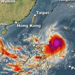
Typhoon SOULIK/07W at the northern limits …

The strong Tropical Storm (TS) SOULIK/07W has again strengthened and is now a Typhoon Cat.1. This system is moving west at the northern limits of the zone that could become dangerous for the Philippines.

The danger zone is marked red on our new weather page. The animated 24 hours movie shows that typhoon SOULIK / 07W is moving exactly on the northern boundary of this zone.
Typhoon SOULIK / 07W is expected to maintain its west-northwest track throughout the forecast period. On the forecast track, the core of SOULIK / 07W will enter the northeastern border of the Philippine Area of Responsibility (PAR) on Wednesday. It then should be a Typhoon Cat.2.
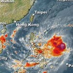
By Thursday the storm should become severe Typhoon as it nears Category 3 status.
On Friday typhoon SOULIK / 07W will Approach the Yaeyama and Ishigakijima Islands with wind speeds of about 195 km/h.
Related posts
 November 18, 2015 Tropical Storm IN-FA moving west Tropical Storm IN-FA is moving west. This storm is still far away from the Philippines but has the potential to amplify to a Typhoon Cat. […]
- October 15, 2015 Tropical Storm KOPPU/Lando a bit slower Tropical Storm KOPPU/Lando advanced a bit slower than forecasts predicted. While still moving westward it gained a bit of strength. The […]
- October 14, 2015 Tropical Storm KOPPU/Lando straight westward Tropical Storm KOPPU/Lando continues on its westward track. It has slightly slowed down the forward speed from 25 to 20 km/h. It has […]
- October 13, 2015 Two Tropical Depressions in a row Two Tropical Depressions in a row are approaching the Philippines. The nearer one at 142° E, is moving westward at 15 km/h. The second one […]
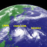
- July 8, 2015 CHAN-HOM and NANGKA – Habagat Amplifiers Last weekend, Tropical Storm LINFA/Egay brought a lot of rain over northern Luzon. Now it is enhancing the southwest monsoon (Habagat) […]


Recent Comments