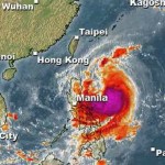
Typhoon KOPPU/Lando now Category 3

Typhoon KOPPU/Lando gained strength and is now a Typhoon Category 3. The cyclone has slowly approached the Philippines and is now 285 km East of Baler, Aurora. It moves westward at 10 km/h.
The Potential Landfall Area will be along the shores of Aurora by early Sunday morning. Possible coastal storm surge flooding of 1 to 6 m (3 to 20 ft) above normal tide levels is to be expected in Camarines Norte, Northern Camarines Sur (Partido), Northern Catanduanes, Polillo Islands and along Eastern Isabela and Northern Aurora. Storm Surge is the wave front a cyclone pushes ahead of its eye.
Wind speeds are now 160 km/h near the centre and 220 km/h in gusts.
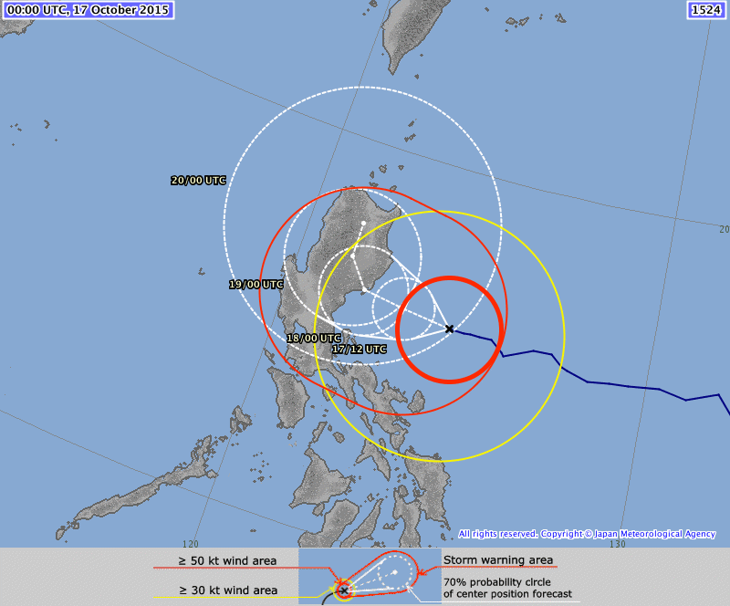
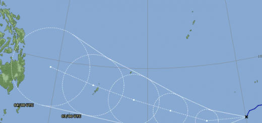
Typhoon KOPPU/Lando track forecast
All meteorological agencies in south east Asia show almost the same tracks. We usually use the tracks of JMA because of their precision and their easy reading. The white dotted circles show the possible future centre position of the typhoon. The thick red circles shows the current zone of winds stronger than 50 knots (90 km/h). The yellow circle shows the current zone of winds stronger than 30 knots (55 km/h). And the thin red zone shows the forecast area of strong storm winds with than 50 knots (90 km/h).
PAGASA Storm Signals
Storm Signal #3: winds of 121 to 170 kph within 18 hours
Aurora, Isabela, Quirino, Nueva Vizcaya, Nueva Ecija, Ifugao, Northern Quezon including Polillo Islands
Storm Signal #2: winds of 61 to 120 kph within 24 hours
Cagayan including Calayan and Babuyan group of Islands, Benguet, Mt. Province, Abra, Kalinga, Apayao, Pangasinan, La Union, Ilocos Sur, Ilocos Norte, Bulacan, Pampanga, Tarlac, Rizal, rest of Quezon, Camarines Norte, Catanduanes
Storm Signal #1: winds of 30 to 60 kph within 36 hours
Batanes, Zambales, Bataan, Cavite, Laguna, Batangas, Albay, Camarines Sur, Metro Manila
KOPPU/Lando Storm data:
| Name (INTL. / local): | KOPPU/Lando |
| Class: | Typhoon Category 3 |
| Time/Date of observation: | 10:30 AM on October 17, 2015 |
| Location of Center: | 15.6° North 124.0° East |
| Moving Direction and Speed: | West @ 10 km/h |
| Moving towards: | Northern Luzon |
| Distance from the Philippines: | 285 km E of Baler (Aurora) |
| Estimated Date / Time of Landfall: | Sunday morning, Aurora |
| Max. Wind Speed near Center: | 160 km/h |
| Peak Wind Gusts: | 220 km/h |
| Minimum Central Pressure: | 940 hPa |
| Diameter: | 600km |
| 24h Rainfall near Center: | 100 – 500 mm |
| Max. Wave Height: | 6-8 m Gale Warning |
| Here you find how to read and understand this data | |
Nearly real-time storm information
Next update this afternoon maybe.
[GARD]
Related posts
 October 18, 2015 Too slow! Typhoon KOPPU/Lando creeps over land Too slow! Typhoon KOPPU/Lando moves only very slowly northwest. Forward speeds are between 3 and 9 km/h! The Typhoon continues to bring […]
- October 18, 2015 Landfall over Casiguran – Aurora Super Typhoon KOPPU/Lando has made Landfall between Baler and Casiguran in Aurora province around 01:00 a.m. this morning. Cyclonic winds […]
- October 17, 2015 Great Danger in Aurora – Typhoon KOPPU/Lando now Cat.4 Great Danger in Aurora - Typhoon KOPPU/Lando has now developed an eye and has been upgraded to Category 4. PAGASA has hoisted Storm SIgnal […]
- October 16, 2015 Typhoon KOPPU/Lando is now affecting the Philippines Typhoon KOPPU/Lando is already near and upgraded to Cat.2. PAGASA sees it 510 km off the coast of Aurora. The strong winds and heavy […]
- October 16, 2015 Typhoon KOPPU/Lando brings first heavy rains Typhoon KOPPU/Lando brings the first heavy rains to the Philippines. Winds on the north-east coast are now stronger than 30 knots (55 […]


Recent Comments