Too slow! Typhoon KOPPU/Lando creeps over land
Too slow! Typhoon KOPPU/Lando moves only very slowly northwest. Forward speeds are between 3 and 9 km/h! The Typhoon continues to bring heavy rainfall and very strong winds to northern Luzon provinces.
I happens only rarely that a typhoon moves so slowly. Average forward speeds are 15 to 25 km/h. But KOPPU/Lando moves at 3 to 9 km/h. Too Slow! Much too slow! JMA even does not indicate forward speeds anymore, they only write “Slowly”. The problem of this non-moving cyclone is that it continues to bring heavy rainfall and strong winds not only during a few hours, but obviously for several days. The strength has decreased and KOPPU/Lando is now a Typhoon Category 2.
This long period of heavy to extreme rainfalls dramatically increases the danger of floods and landslides. The mountain slopes in the northern provinces are steep. Once the roads will be damaged or destroyed by the landslides, it won’t be possible to bring relief goods to the people up there. This situation may trigger a big humanitarian catastrophe.
Too slow! Typhoon KOPPU/Lando
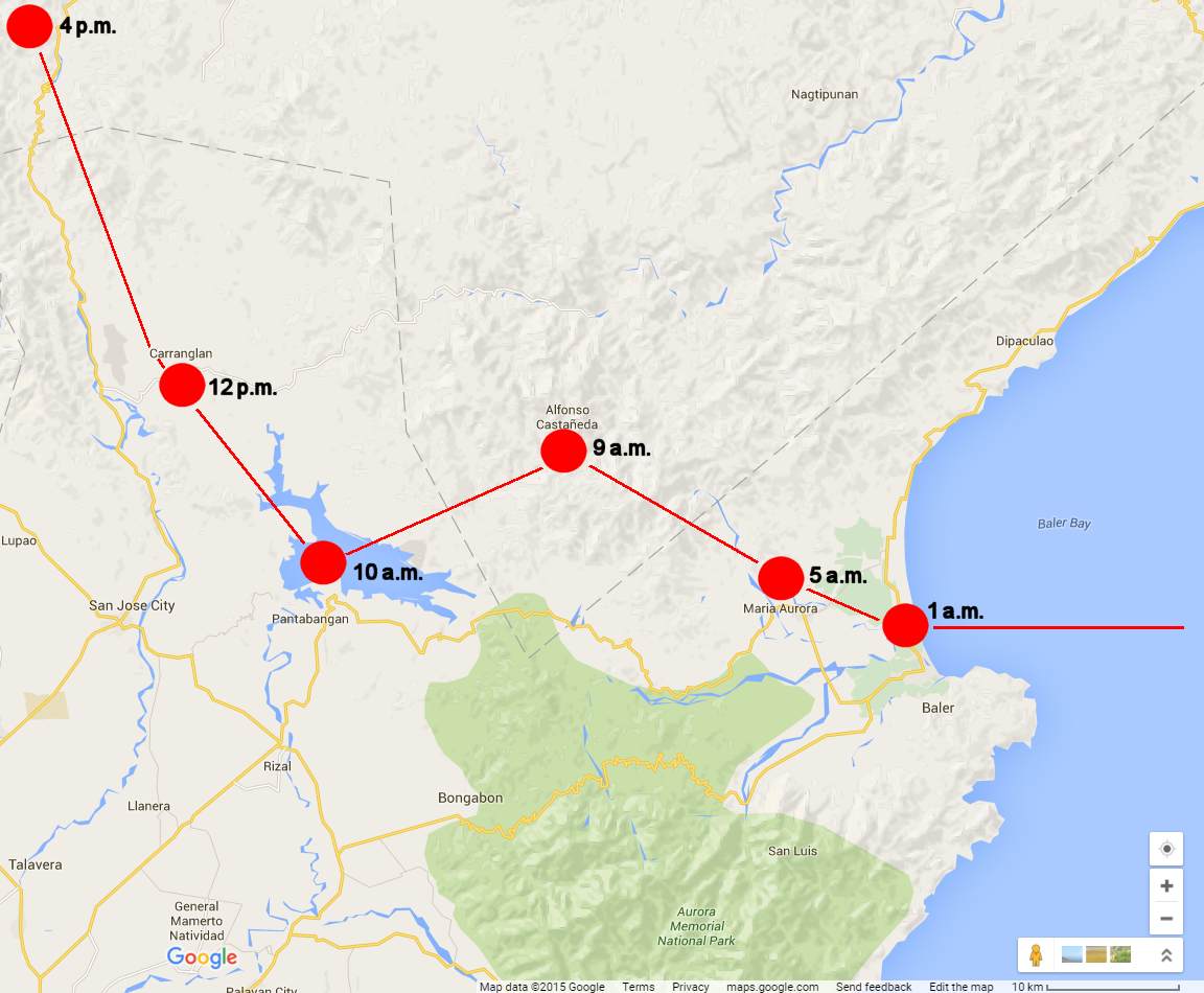
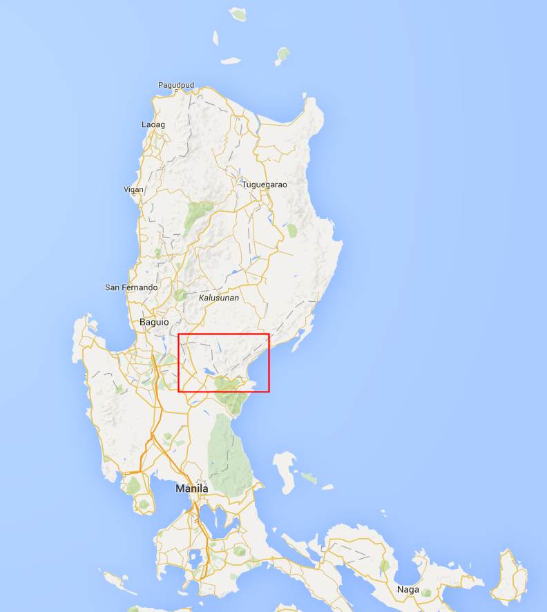
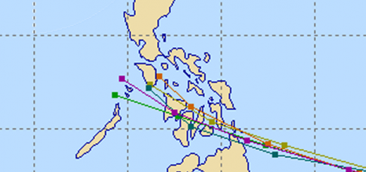
Above map shows the creeping path of slow Typhoon KOPPU/Lando. The red rectangle in the map below corresponds to above region.
Typhoon KOPPU/Lando track forecast

JMA always publishes excellent forecast tracks. IMPORTANT: The time in the upper left corner is UTC. Here in the Philippines we have UTC+8. This means that above forecast is from 9+8=17. 17:00 hours or 5:00 p.m.
PAGASA Storm Signals
Storm Signal #3: winds of 121 to 170 kph within 18 hours
Nueva Ecija, Quirino, Nueva Vizcaya, Benguet, Ifugao, Mountain Province, Kalinga, Ilocos Sur, La Union, Pangasinan and Zambales
Storm Signal #2: winds of 61 to 120 kph within 24 hours
Cagayan including Calayan and Babuyan group of Islands, Isabela, Aurora, Abra, Apayao, Ilocos Norte, Bataan, Tarlac, Pampanga, Bulacan, Rizal, Northern Quezon including Polillo Islands and Metro Manila
Storm Signal #1: winds of 30 to 60 kph within 36 hours
Batanes,Cavite, Laguna, Batangas and rest of Quezon
KOPPU/Lando Storm data:
| Name (INTL. / local): | KOPPU/Lando |
| Class: | Typhoon Category 2 |
| Time/Date of observation: | 05:00 PM on October 18, 2015 |
| Location of Center: | 16.2° North 121.0° East |
| Moving Direction and Speed: | West @ 3-9 km/h !!! |
| Moving towards: | Northern Luzon |
| Distance from the Philippines: | Santa Fe, Nueva Vizcaya |
| Estimated Date / Time of Landfall: | This morning @ 1 a.m. |
| Max. Wind Speed near Center: | 160 km/h |
| Peak Wind Gusts: | 185 km/h |
| Minimum Central Pressure: | 945 hPa |
| Diameter: | 750 km |
| 24h Rainfall near Center: | 100 – 500 mm |
| Max. Wave Height: | n/a (over land) |
| Here you find how to read and understand this data | |
Nearly real-time storm information
Next update tomorrow, if we have sun or power.
[GARD]
Related posts
 October 16, 2015 Typhoon KOPPU/Lando is now affecting the Philippines Typhoon KOPPU/Lando is already near and upgraded to Cat.2. PAGASA sees it 510 km off the coast of Aurora. The strong winds and heavy […]
- October 16, 2015 Typhoon KOPPU/Lando brings first heavy rains Typhoon KOPPU/Lando brings the first heavy rains to the Philippines. Winds on the north-east coast are now stronger than 30 knots (55 […]
- October 20, 2015 Cyclone KOPPU/Lando – full of surprises Cyclone KOPPU/Lando had been and still is full of surprises. First the good news - the storm is continuously weakening and it still stays […]
- October 18, 2015 Landfall over Casiguran – Aurora Super Typhoon KOPPU/Lando has made Landfall between Baler and Casiguran in Aurora province around 01:00 a.m. this morning. Cyclonic winds […]
- October 17, 2015 Great Danger in Aurora – Typhoon KOPPU/Lando now Cat.4 Great Danger in Aurora - Typhoon KOPPU/Lando has now developed an eye and has been upgraded to Category 4. PAGASA has hoisted Storm SIgnal […]


Recent Comments