Tropical Storm KONG-REY / Nando menacing Batanes Islands
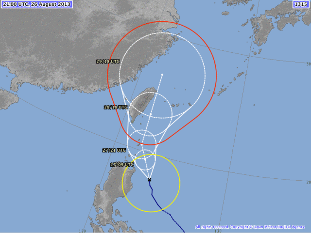
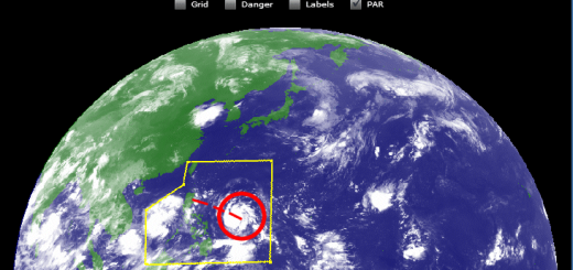
Tropical Storm KONG-REY / Nando has again intensified during the night. At 07:00 a.m. the storm was 190km east of Aparri, Cagayan. It is moving north-northwest at 8 km/h. Winds blow with 65 to 85 km/h. Rainfall is extreme at 45 centimeters in 24 hours.
This storm is amplifying the southwest monsoon (Habagat) as its predecessor (TRAMI / Maring) did last week. Fortunately the suction is not as strong, but it still brings slight to moderate to sometimes heavy rains across the western sections of Luzon. The threat of Flash floods and landslides are likely in hazard-prone areas especially along river banks and mountain slopes of the affected areas.
JMA’s storm track forecast is the most western one. All other agencies predict that the storm turns north within a few hours and the veers north-east.
PAGASA declares the follwing storm warnings:
Signal No. 2 (61-100 km/h winds)
– Batanes Group of Islands
Signal No. 1 (65-60 km/h winds)
– Cagayan
– Calayan
– Babuyan Group of Islands
– Apayao
– Isabela
Related posts
 September 2, 2013 Landslide – what landslide? It’s sunny in the Philippines People ask me often about our landslide warnings. Most tourists cannot imagine what it means. Landslide? What is sliding?
Our northern […]
September 2, 2013 Landslide – what landslide? It’s sunny in the Philippines People ask me often about our landslide warnings. Most tourists cannot imagine what it means. Landslide? What is sliding?
Our northern […]- August 27, 2013 Tropical Storm KONG-REY / Nando is moving North Tropical Storm KONG-REY / Nando is moving North. The storm has slightly accelerated northward with no change in strength. At 11:00 […]
- November 18, 2015 Tropical Storm IN-FA moving west Tropical Storm IN-FA is moving west. This storm is still far away from the Philippines but has the potential to amplify to a Typhoon Cat. […]
- July 8, 2015 CHAN-HOM and NANGKA – Habagat Amplifiers Last weekend, Tropical Storm LINFA/Egay brought a lot of rain over northern Luzon. Now it is enhancing the southwest monsoon (Habagat) […]
- May 10, 2015 Tropical Storm DOLPHIN – The next bad guy? You may remember our storm report from May 8. We then reported a strange guy developing around Palikir, Micronesia. This strange guy now […]


Recent Comments