Warning: Tropical Storm 22W is developing quickly
This morning we announced that a new Low Pressure Area is developing. This LPA developed extremely fast during the day and has already been upgraded to a Tropical Storm.
All weather agencies had been too conservative this morning. Everybody expected the Low Pressure Are to develop into a Tropical Depression by tomorrow. Now it has already the strength of a Tropical Storm. This Cyclone is heading towards the Philippines and should reach our islands end of this week. The waters in the Pacific north of the equator are very warm, over 30°C. This will provide the cyclone with plenty of energy. Worse, there seem to be no high atmosphere streams that could disturb the cyclogenesis.
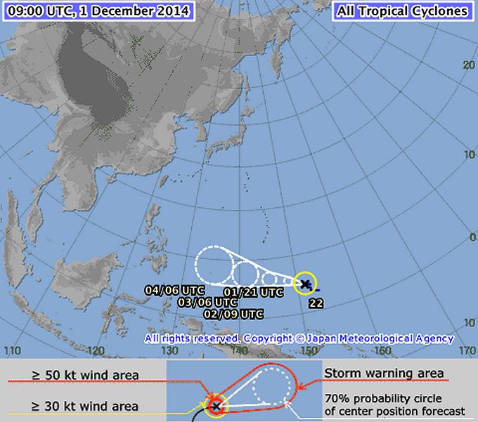
This Tropical Storm is moving at a forward speed of 25 km/h in direction west to northwest. It has a central pressure of 1000 hPa and wind speed near the center is 35-50 kt (55-92 km/h). The storm is expected to increase the forward speed to 30 km/h. The central pressure will constantly decrease by about 2 to 4 hPa in 24 hours.
JMA is still conservative
An extrapolation of these white probability circles makes us think that the cyclone will hit either Samar or Bicol. It is much too early to give a serious advice. We expect to have enough data on Wednesday.
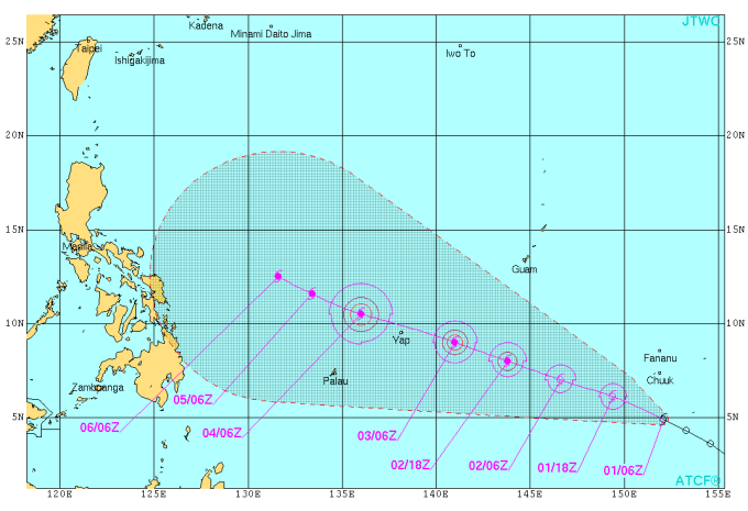
JTWC outlook goes much farther
The US Navy looks much more ahead. Their forecast points much more to north, towards northern Luzon.
Please don’t panic now. Read the news and listen to the radio and watch TV. Or stay with us 😉
Silent Gardens tries to warn as soon as possible. Only with early warning you can re-book flights or change ferry tickets.
We’ll inform again tomorrow morning about the new Tropical Storm. We wish you a good night.
[GARD]
Related posts
 July 19, 2014 MATMO Henry could become dangerous Tropical Storm MATMO/Henry continued on a nearly westward track and approached the Philippine islands during the last 24 hours. This […]
- November 18, 2015 Tropical Storm IN-FA moving west Tropical Storm IN-FA is moving west. This storm is still far away from the Philippines but has the potential to amplify to a Typhoon Cat. […]
- July 8, 2015 CHAN-HOM and NANGKA – Habagat Amplifiers Last weekend, Tropical Storm LINFA/Egay brought a lot of rain over northern Luzon. Now it is enhancing the southwest monsoon (Habagat) […]
- May 10, 2015 Tropical Storm DOLPHIN – The next bad guy? You may remember our storm report from May 8. We then reported a strange guy developing around Palikir, Micronesia. This strange guy now […]
- March 17, 2015 Tropical Storm BAVI plays tricks Tropical Storm BAVI plays tricks with observers and forecasters. The storm slowed down its forward speed to 25 km/h. The track direction […]


Recent Comments